File:Sunset over the Soda Mountains and the Barstow Freeway (Interstate Highway 15) east of Baker, California LCCN2013630771.tif

Size of this JPG preview of this TIF file: 800 × 507 pixels. Other resolutions: 320 × 203 pixels | 640 × 406 pixels | 1,024 × 649 pixels | 1,280 × 812 pixels | 2,560 × 1,624 pixels | 6,917 × 4,387 pixels.
Original file (6,917 × 4,387 pixels, file size: 173.67 MB, MIME type: image/tiff)
Captions
Captions
Add a one-line explanation of what this file represents
Summary edit
| Description |
English: Title: Sunset over the Soda Mountains and the Barstow Freeway (Interstate Highway 15) east of Baker, California
Physical description: 1 photograph : digital, tiff file, color. Notes: Title, date, and keywords provided by the photographer.; Credit line: The Jon B. Lovelace Collection of California Photographs in Carol M. Highsmith's America Project, Library of Congress, Prints and Photographs Division.; Gift; The Capital Group Companies Charitable Foundation in memory of Jon B. Lovelace; 2012; (DLC/PP-2012:063).; Forms part of: Jon B. Lovelace Collection of California Photographs in Carol M. Highsmith's America Project in the Carol M. Highsmith Archive. |
||||||||||||||||||||||||||
| Date | Taken on 21 December 2012, 17:53 (according to Exif data) | ||||||||||||||||||||||||||
| Source |
Library of Congress
|
||||||||||||||||||||||||||
| Author |
|
||||||||||||||||||||||||||
| Permission (Reusing this file) |
No known restrictions on publication.
|
||||||||||||||||||||||||||


| Camera location | | View this and other nearby images on: OpenStreetMap |
|---|
Licensing edit
| This work is from the Carol M. Highsmith Archive collection at the Library of Congress. According to the library, there are no known copyright restrictions on the use of this work. Carol M. Highsmith has stipulated that her photographs are in the public domain. Photographs of sculpture or other works of art may be restricted by the copyright of the artist. |
 |
File history
Click on a date/time to view the file as it appeared at that time.
| Date/Time | Thumbnail | Dimensions | User | Comment | |
|---|---|---|---|---|---|
| current | 17:11, 23 September 2016 |  | 6,917 × 4,387 (173.67 MB) | Fæ (talk | contribs) | LOC 2013630771, Carol M. Highsmith collection. P4940.19744 TIFF (173.7mb) |
| 17:11, 23 September 2016 | 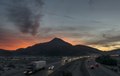 | 6,917 × 4,387 (173.67 MB) | Fæ (talk | contribs) | LOC 2013630771, Carol M. Highsmith collection. P4940.19744 TIFF (173.7mb) |
You cannot overwrite this file.
File usage on Commons
The following page uses this file: