File:Super Mushshak operators.png

Size of this preview: 800 × 407 pixels. Other resolutions: 320 × 163 pixels | 640 × 325 pixels | 1,024 × 521 pixels | 1,280 × 651 pixels | 2,753 × 1,400 pixels.
Original file (2,753 × 1,400 pixels, file size: 91 KB, MIME type: image/png)
Captions
Captions
Add a one-line explanation of what this file represents
Summary edit
| Description |
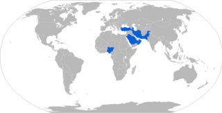
English: Map with military Super Mushshak operators in blue |
| Date | |
| Source | Own work |
| Author | Jurryaany |
Licensing edit
I, the copyright holder of this work, hereby publish it under the following license:
This file is licensed under the Creative Commons Attribution-Share Alike 4.0 International license.
- You are free:
- to share – to copy, distribute and transmit the work
- to remix – to adapt the work
- Under the following conditions:
- attribution – You must give appropriate credit, provide a link to the license, and indicate if changes were made. You may do so in any reasonable manner, but not in any way that suggests the licensor endorses you or your use.
- share alike – If you remix, transform, or build upon the material, you must distribute your contributions under the same or compatible license as the original.
File history
Click on a date/time to view the file as it appeared at that time.
| Date/Time | Thumbnail | Dimensions | User | Comment | |
|---|---|---|---|---|---|
| current | 16:23, 19 March 2019 | | 2,753 × 1,400 (91 KB) | Jurryaany (talk | contribs) | Removed Iraq and Syria |
| 14:41, 26 July 2017 |  | 2,753 × 1,400 (91 KB) | Jurryaany (talk | contribs) | Re-added Syria, accidentally removed in previous edit | |
| 14:34, 26 July 2017 |  | 2,753 × 1,400 (91 KB) | Jurryaany (talk | contribs) | Added Azerbaijan per article change | |
| 16:41, 24 November 2016 |  | 2,753 × 1,400 (91 KB) | Jurryaany (talk | contribs) | Added Turkey per article update | |
| 16:41, 24 November 2016 |  | 2,753 × 1,400 (91 KB) | Jurryaany (talk | contribs) | Added Turkey per article update | |
| 07:02, 5 August 2016 |  | 2,753 × 1,400 (91 KB) | Jurryaany (talk | contribs) | Removed South Africa - operators were private, not military | |
| 06:55, 5 August 2016 |  | 2,753 × 1,400 (91 KB) | Jurryaany (talk | contribs) | User created page with UploadWizard |
You cannot overwrite this file.
File usage on Commons
The following 16 pages use this file:
- User:Chumwa/OgreBot/Potential transport maps/2016 August 1-10
- User:Chumwa/OgreBot/Potential transport maps/2016 November 21-30
- User:Chumwa/OgreBot/Potential transport maps/2017 July 21-31
- User:Chumwa/OgreBot/Potential transport maps/2019 March 11-20
- User:Chumwa/OgreBot/Transport Maps/2016 August 1-10
- User:Chumwa/OgreBot/Transport Maps/2016 November 21-30
- User:Chumwa/OgreBot/Transport Maps/2017 July 21-31
- User:Chumwa/OgreBot/Transport Maps/2019 March 11-20
- User:Chumwa/OgreBot/Travel and communication maps/2016 August 1-10
- User:Chumwa/OgreBot/Travel and communication maps/2016 November 21-30
- User:Chumwa/OgreBot/Travel and communication maps/2017 July 21-31
- User:Chumwa/OgreBot/Travel and communication maps/2019 March 11-20
- Commons:WikiProject Aviation/recent uploads/2016 August 5
- Commons:WikiProject Aviation/recent uploads/2016 November 24
- Commons:WikiProject Aviation/recent uploads/2017 July 26
- Commons:WikiProject Aviation/recent uploads/2019 March 19
File usage on other wikis
The following other wikis use this file:
- Usage on az.wikipedia.org
- Usage on en.wikipedia.org
- Usage on tr.wikipedia.org