File:Surveyor 1 SP-168 p58a.jpg

Size of this preview: 800 × 168 pixels. Other resolution: 1,121 × 235 pixels.
Original file (1,121 × 235 pixels, file size: 32 KB, MIME type: image/jpeg)
Captions
Captions
Add a one-line explanation of what this file represents
Summary edit
| Description |
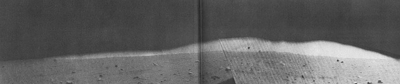
English: One of Surveyor l's most interesting telephoto views was of a mountain range about 16 miles northeast of the spacecraft. E. C. MORRIS, of the U.S. Geological Survey, described it as follows:
"The landing site was within a large, ancient crater, more than 60 miles in diameter, buried by mare material. "The mountain range shown here is part of the rim of this nearly buried crater. The highest peak rises more than 1300 feet above the lunar surface, but only the upper 600 feet project above the near horizon, which is little more than a mile away. The observable crest of the range extends approximately 3 miles along the horizon." This crater is now designated Flamsteed P, and may be referred to as the "Flamsteed ring." |
| Date | |
| Source | EXPLORING SPACE WITH A CAMERA, Section 2, To the Moon and Beyond, Special Publication 168 (SP-168), Compiled and Edited by Edgar M. Cortright, Scientific and Technical Information Division, OFFICE OF TECHNOLOGY UTILIZATION, NATIONAL AERONAUTICS AND SPACE ADMINISTRATION. Washington, D.C., 1968 |
| Author | NASA |
Licensing edit
| This file is in the public domain in the United States because it was solely created by NASA. NASA copyright policy states that "NASA material is not protected by copyright unless noted". (See Template:PD-USGov, NASA copyright policy page or JPL Image Use Policy.) | ||
 |
Warnings:
|
File history
Click on a date/time to view the file as it appeared at that time.
| Date/Time | Thumbnail | Dimensions | User | Comment | |
|---|---|---|---|---|---|
| current | 19:39, 26 February 2017 | 1,121 × 235 (32 KB) | Jstuby (talk | contribs) | User created page with UploadWizard |
You cannot overwrite this file.
File usage on Commons
The following page uses this file:
File usage on other wikis
The following other wikis use this file:
- Usage on en.wikipedia.org