File:Susquehanna River to Schuylkill River, Chesapeake Bay to Delaware Bay. NYPL484199.tiff

Size of this JPG preview of this TIF file: 727 × 600 pixels. Other resolutions: 291 × 240 pixels | 582 × 480 pixels | 931 × 768 pixels | 1,241 × 1,024 pixels | 2,483 × 2,048 pixels | 4,991 × 4,117 pixels.
Original file (4,991 × 4,117 pixels, file size: 58.79 MB, MIME type: image/tiff)
Captions
Captions
Add a one-line explanation of what this file represents
Summary edit
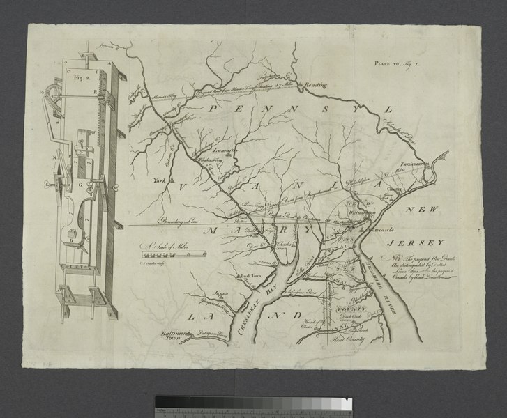
| Description | [Susquehanna River to Schuylkill River, Chesapeake Bay to Delaware Bay.; Lawrence H. Slaughter Collection of English maps, charts, globes, books and atlases / Charts and maps | |||||||||||||||||||||||
| Notes | Covers southeastern Pa., northeastern Md., and northern Del. ''Note 2.'') Title supplied by cataloger. ''Note 3.'') Includes "Fig. 2," a technical ill. ''Note 4.'') From Transactions of the American Philosophical Society. Volume I. From January 1st, 1769, to January 1st, 1771. ''Note 5.'') Map to accompany "An abstract of sundry papers and proposals for improving the inland navigation of Pennsylvania and Maryland, by opening a communication between the tide-waters of Delaware and Susquehannah, or Chesapeake Bay ... " | |||||||||||||||||||||||
| Item physical description | 1 map; on sheet 36 x 48 cm. | |||||||||||||||||||||||
| Catalogue call number | Map Div. 97-6016 [LHS 240] | |||||||||||||||||||||||
| Standard reference | Later issue in Papenfuse and Coale. Atlas of historical maps of Maryland, p. 65, figure 68 | |||||||||||||||||||||||
| Date | ||||||||||||||||||||||||
| Source |
http://digitalgallery.nypl.org/nypldigital/dgkeysearchdetail.cfm?imageID=484199
|
|||||||||||||||||||||||
| Author | James - Engraver Smither | |||||||||||||||||||||||
| Permission (Reusing this file) |
From The Lionel Pincus and Princess Firyal Map Division. http://maps.nypl.org
|
|||||||||||||||||||||||
| Location | Stephen A. Schwarzman Building / The Lionel Pincus and Princess Firyal Map Division | |||||||||||||||||||||||
| Digital item published | 2-28-2005; updated 3-25-2011 | |||||||||||||||||||||||
| Digital ID | 484199 | |||||||||||||||||||||||

The making of this file was supported by Wikimedia UK.
To see other files made with the support of Wikimedia UK, please see the category Supported by Wikimedia UK.
|
File history
Click on a date/time to view the file as it appeared at that time.
| Date/Time | Thumbnail | Dimensions | User | Comment | |
|---|---|---|---|---|---|
| current | 19:28, 5 May 2014 |  | 4,991 × 4,117 (58.79 MB) | Fæ (talk | contribs) | GWToolset: Creating mediafile for Fæ. Tranche 3 17512-20314 @ 11:54, 3 March 2014 |
You cannot overwrite this file.
File usage on Commons
There are no pages that use this file.
File usage on other wikis
The following other wikis use this file:
- Usage on www.wikidata.org