File:Sykes picot-he.jpg
Sykes_picot-he.jpg (452 × 433 pixels, file size: 45 KB, MIME type: image/jpeg)
File information
Structured data
Captions
Captions
Add a one-line explanation of what this file represents
Summary edit
| DescriptionSykes picot-he.jpg |
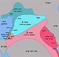
Français : carte du découpage du Moyen-Orient suivant les accords Sykes-Picot.
עברית: המזרח התיכון על פי סייקס-פיקו. הכתם הצהוב סביב חיפה מסמן את המובלעת הבריטית בין חיפה ועכו. |
| Date | |
| Source |
This file was derived from: Sykes picot.jpg |
| Author |
|
| This is a retouched picture, which means that it has been digitally altered from its original version. Modifications: translate to Hebrew. The original can be viewed here: Sykes picot.jpg:
|
| This is a retouched picture, which means that it has been digitally altered from its original version. Modifications: e. The original can be viewed here: Sykes picot-he.jpg:
|
| This is a retouched picture, which means that it has been digitally altered from its original version. Modifications: הוספת המובלעת הבריטית בין חיפה לעכו (בצהוב). על פי ההסכם הרשמי+הוספת המובלעת הבריטית בין חיפה לעכו (בצהוב). על פי ההסכם הרשמי. The original can be viewed here: Sykes picot-he.jpg:
|
Licensing edit
This file is licensed under the Creative Commons Attribution-Share Alike 3.0 Unported license.
Attribution: GFDL
- You are free:
- to share – to copy, distribute and transmit the work
- to remix – to adapt the work
- Under the following conditions:
- attribution – You must give appropriate credit, provide a link to the license, and indicate if changes were made. You may do so in any reasonable manner, but not in any way that suggests the licensor endorses you or your use.
- share alike – If you remix, transform, or build upon the material, you must distribute your contributions under the same or compatible license as the original.

|
Permission is granted to copy, distribute and/or modify this document under the terms of the GNU Free Documentation License, Version 1.2 or any later version published by the Free Software Foundation; with no Invariant Sections, no Front-Cover Texts, and no Back-Cover Texts. A copy of the license is included in the section entitled GNU Free Documentation License.http://www.gnu.org/copyleft/fdl.htmlGFDLGNU Free Documentation Licensetruetrue |
File history
Click on a date/time to view the file as it appeared at that time.
| Date/Time | Thumbnail | Dimensions | User | Comment | |
|---|---|---|---|---|---|
| current | 17:09, 22 December 2016 |  | 452 × 433 (45 KB) | קובץ על יד (talk | contribs) | הוספת המובלעת הבריטית בין חיפה לעכו (בצהוב). על פי ההסכם הרשמי |
| 17:06, 22 December 2016 |  | 452 × 433 (45 KB) | קובץ על יד (talk | contribs) | הוספת המובלעת הבריטית בין חיפה לעכו (בצהוב). על פי ההסכם הרשמי | |
| 09:33, 19 August 2009 |  | 452 × 433 (28 KB) | Ori~ (talk | contribs) | e | |
| 07:53, 19 August 2009 |  | 452 × 433 (107 KB) | רוליג (talk | contribs) | {{Information |Description=carte du découpage du Moyen-Orient suivant les accords Sykes-Picot |Source=File:Sykes picot.jpg /self-translate |Date=190809 |Author= רוליג |Permission= |other_versions= }} __NOTOC__ [[Category:Maps of |
You cannot overwrite this file.
File usage on Commons
The following 3 pages use this file:
File usage on other wikis
The following other wikis use this file:
- Usage on he.wikipedia.org
- 16 במאי
- ויקיפדיה:היום בהיסטוריה/מאי
- תבנית:היום בהיסטוריה 16 במאי
- הסכם סייקס–פיקו
- פורטל:מדינות העולם/היום בהיסטוריה/מאי
- פורטל:מדינות העולם/היום בהיסטוריה/16 במאי
- מלחמת טורקיה–צרפת
- פורטל:היישוב/היום בהיסטוריה/מאי
- פורטל:היישוב/היום בהיסטוריה/16 במאי
- ויקיפדיה:סדנה לגרפיקה/ארכיון 4
- היסטוריה של הסכסוך הישראלי-פלסטיני
- פורטל:תולדות עם ישראל/היום בתולדות עם ישראל/אפריל
- פורטל:תולדות עם ישראל/היום בתולדות עם ישראל/25 באפריל
- ויקיפדיה:סדנה לגרפיקה/ארכיון 40
- פורטל:צרפת/היום בהיסטוריה/מאי
- פורטל:צרפת/היום בהיסטוריה/16 במאי
- גבול ירדן–סוריה
- 1916 בצרפת
Metadata
This file contains additional information such as Exif metadata which may have been added by the digital camera, scanner, or software program used to create or digitize it. If the file has been modified from its original state, some details such as the timestamp may not fully reflect those of the original file. The timestamp is only as accurate as the clock in the camera, and it may be completely wrong.
| Width | 452 px |
|---|---|
| Height | 433 px |
| Bits per component |
|
| Pixel composition | RGB |
| Orientation | Normal |
| Number of components | 3 |
| Horizontal resolution | 72 dpi |
| Vertical resolution | 72 dpi |
| Software used | Adobe Photoshop CS5 Windows |
| File change date and time | 17:59, 22 December 2016 |
| Exif version | 2.21 |
| Color space | Uncalibrated |
| Date and time of digitizing | 19:35, 22 December 2016 |
| Date metadata was last modified | 19:59, 22 December 2016 |
| Unique ID of original document | xmp.did:EE025D965FC8E611B814B31ECCF1F044 |
| IIM version | 225 |
