File:Syr map.PNG
No higher resolution available.
Syr_map.PNG (328 × 352 pixels, file size: 13 KB, MIME type: image/png)
Captions
Captions
Add a one-line explanation of what this file represents
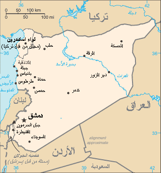
- (English) Subject: map of Syria, with Arabic text.
- (français) Sujet : carte de la Syrie, avec texte en arabe.
- Other versions: Image:Sy-map.png (English text)
- Source: The World Factbook (CIA)
- License:
This image is in the public domain because it contains materials that originally came from the United States Central Intelligence Agency's World Factbook.
|
 |
File history
Click on a date/time to view the file as it appeared at that time.
| Date/Time | Thumbnail | Dimensions | User | Comment | |
|---|---|---|---|---|---|
| current | 18:59, 18 October 2006 | | 328 × 352 (13 KB) | Electionworld (talk | contribs) | *(English) '''Subject:''' map of Syria, with Arabic text. *(français) '''Sujet :''' carte de la Syrie, avec texte en arabe. *'''Other versions:''' Image:Sy-map.png (English text) *'''Source:''' [ |
You cannot overwrite this file.
File usage on Commons
The following 2 pages use this file:
File usage on other wikis
The following other wikis use this file:
- Usage on ar.wikipedia.org
- Usage on bn.wikipedia.org
- Usage on ckb.wikipedia.org
- Usage on fa.wikipedia.org
- Usage on hr.wikipedia.org
- Usage on zh.wikipedia.org