File:Syuparo Lake c 2000.png

Size of this preview: 284 × 599 pixels. Other resolutions: 114 × 240 pixels | 227 × 480 pixels | 364 × 768 pixels | 485 × 1,024 pixels | 2,549 × 5,376 pixels.
Original file (2,549 × 5,376 pixels, file size: 15.61 MB, MIME type: image/png)
Captions
Captions
Add a one-line explanation of what this file represents
Summary edit
| Description |
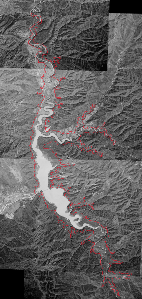
日本語: 1999年の画像1枚と2000年の画像3枚から作成した、大夕張ダム時代のシューパロ湖全景。
赤い線は夕張シューパロダム完成後のシューパロ湖の範囲を示す。 画像中央少し下に大夕張ダムがあり、流れ出す夕張川も確認できる。 大夕張ダムのすぐ東側には三弦橋が見える他、当時のシューパロ湖北端付近には大夕張市街の跡地が確認できる。 |
| Date | |
| Source |
|
| Author |
| Camera location | | View this and other nearby images on: OpenStreetMap |
|---|
Licensing edit

|
The copyright holder of this file, the Ministry of Land, Infrastructure, Transport and Tourism of Japan, allows anyone to use it for any purpose, provided that the copyright holder is properly attributed. Redistribution, derivative work, commercial use, and all other use is permitted. |
Attribution:
Copyright © National Land Image Information (Color Aerial Photographs), Ministry of Land, Infrastructure, Transport and Tourism
|
 |
This image is copyrighted by the Ministry of Land, Infrastructure, Transport and Tourism of Japan. For terms of use, see the stipulation to use of National Land Information (in Japanese) and message from MLIT (in Japanese and English). When you display this image on an article, include the following phrase in the description: "Made based on National Land Image Information (Color Aerial Photographs), Ministry of Land, Infrastructure, Transport and Tourism".
|
File history
Click on a date/time to view the file as it appeared at that time.
| Date/Time | Thumbnail | Dimensions | User | Comment | |
|---|---|---|---|---|---|
| current | 17:22, 4 September 2023 | | 2,549 × 5,376 (15.61 MB) | 寄辺ナキ (talk | contribs) | Uploaded a work by {{ja|国土地理院、寄辺ナキが加工。}} {{en|Geospatial Information Authority of Japan, modified by 寄辺ナキ}} from *国土交通省「国土画像情報(カラー空中写真)」(配布元:国土地理院地図・空中写真閲覧サービス) **[https://mapps.gsi.go.jp/maplibSearch.do?specificationId=115942 HO994X-C5-15] **[https://mapps.gsi.go.jp/maplibSearch.do?specificationId=661244 HO20008Y-C8-5] **[https://mapps.gsi.go.jp/maplibSearch.do?specificationId=120211 HO20008Y-C9-6] **... |
You cannot overwrite this file.
File usage on Commons
There are no pages that use this file.
File usage on other wikis
The following other wikis use this file:
- Usage on ja.wikipedia.org