File:Szekely03.png

Size of this preview: 506 × 600 pixels. Other resolutions: 202 × 240 pixels | 405 × 480 pixels | 648 × 768 pixels | 1,152 × 1,365 pixels.
Original file (1,152 × 1,365 pixels, file size: 100 KB, MIME type: image/png)
Captions
Captions
Add a one-line explanation of what this file represents

|
This map image could be re-created using vector graphics as an SVG file. This has several advantages; see Commons:Media for cleanup for more information. If an SVG form of this image is available, please upload it and afterwards replace this template with
{{vector version available|new image name}}.
It is recommended to name the SVG file “Szekely03.svg”—then the template Vector version available (or Vva) does not need the new image name parameter. |
Summary edit
| Description |
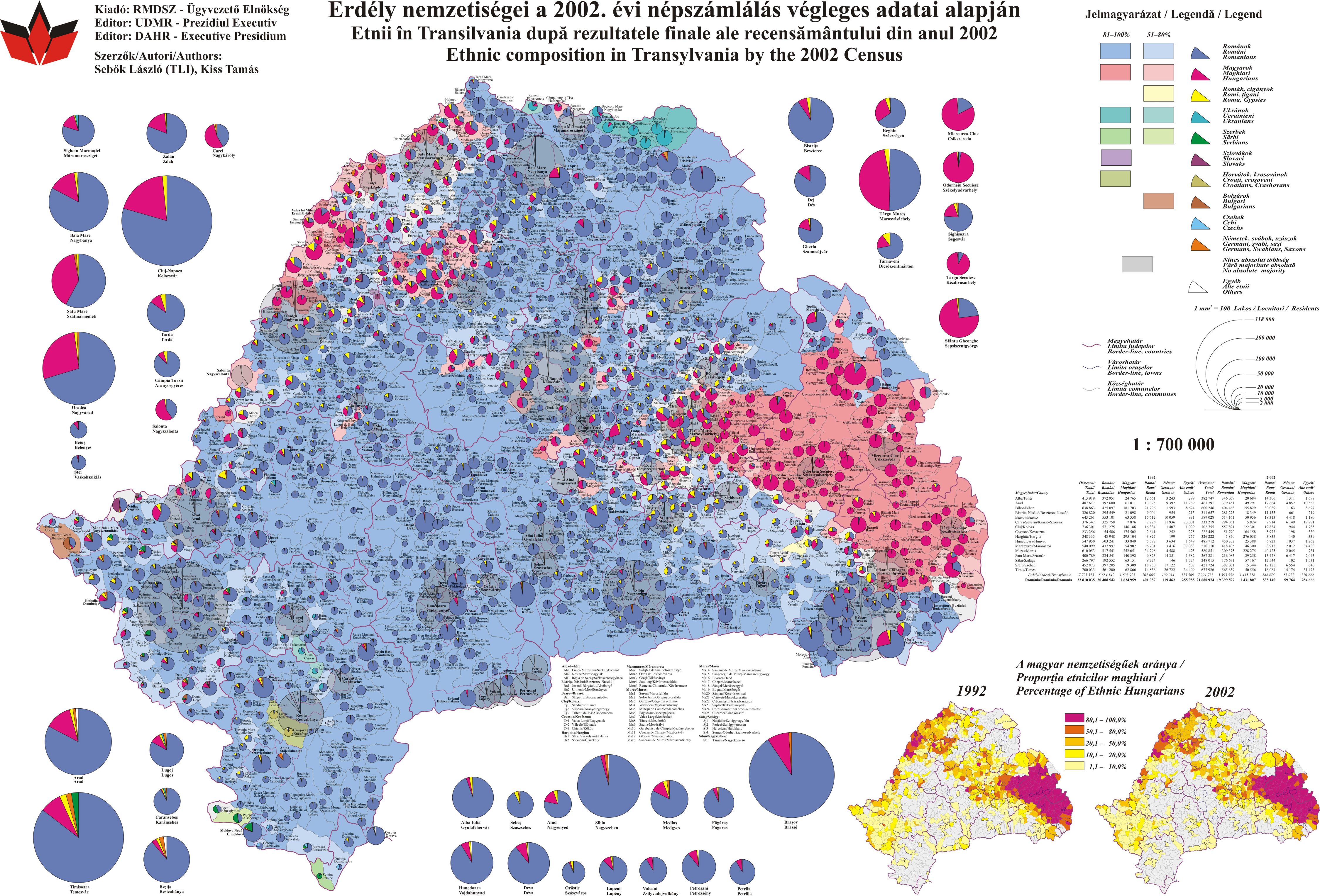
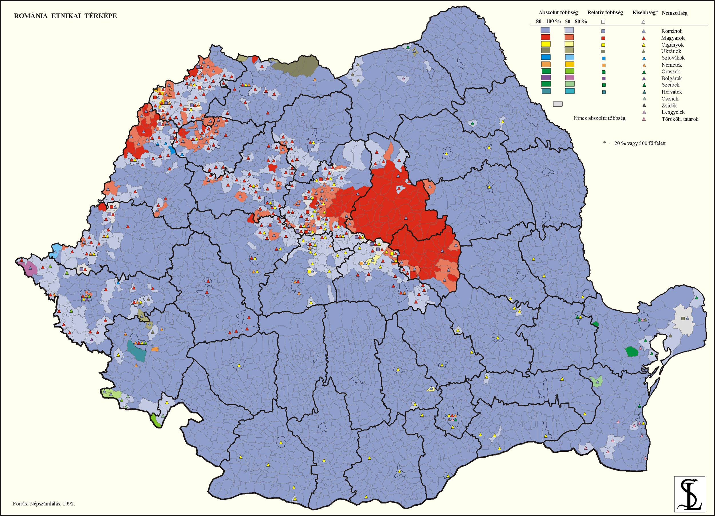
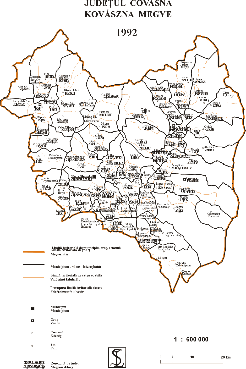
English: Ethnic map of Székelyland (Mureş, Harghita and Covasna counties) in Romania (2002 census data by municipalities). |
||
| Date | 11-4-2007 | ||
| Source | English Wikipedia - Own work - This file was created by user:PANONIAN and was originally uploaded in English Wikipedia few years ago. User:ArdadN then uploaded modified version of this file over original map (with 2002 census data instead 1992) and this modified file (without original version) was moved to Wikimedia Commons by User:Walden69. User:PANONIAN then uploaded original file with 1992 census data under name "Szekely03 original map.png" (here is location of original file: http://commons.wikimedia.org/wiki/File:Szekely03_original_map.png ). | ||
| Author | user:PANONIAN and User:ArdadN | ||
| Permission (Reusing this file) |
|
||
| Other versions | Derivative works of this file: Mures (Maros) county ethnic.PNG |
_county_ethnic.PNG)
Licensing edit
| This work has been released into the public domain by its author, ArdadN. This applies worldwide. In some countries this may not be legally possible; if so: |
References edit
2002 census data:
- http://www.hungarian-human-rights.eu/images/erdely_terkep.jpg
- http://www.edrc.ro/recensamant.jsp?regiune_id=2568&judet_id=0&localitate_id=0
County/municipal borders:
- http://sebok1.adatbank.transindex.ro/kepek/retnikai.jpg
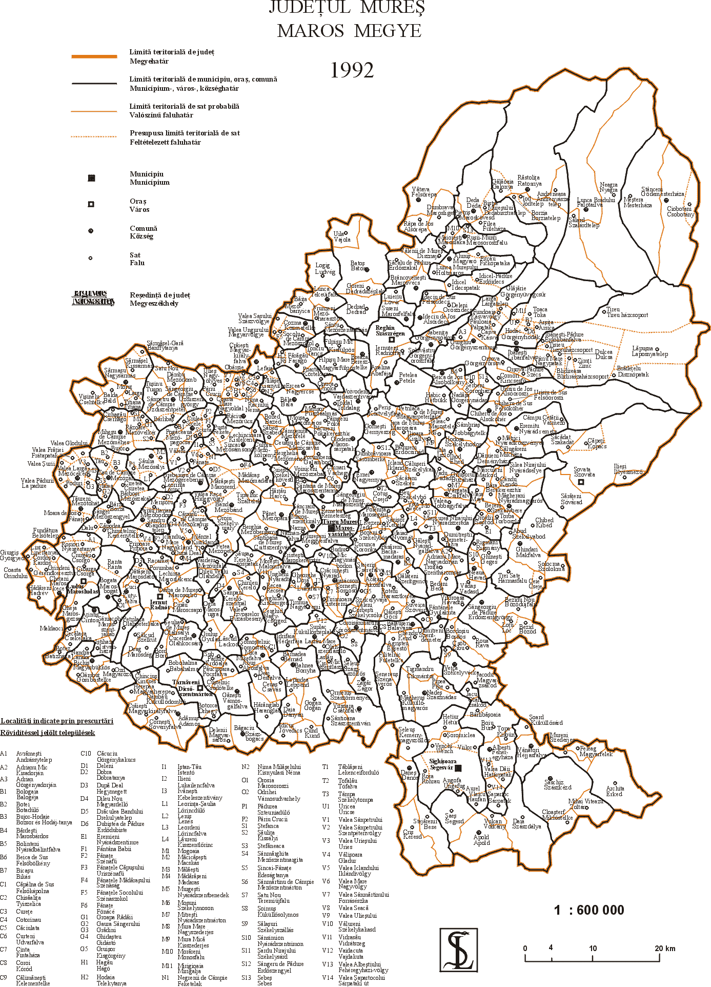
- http://sebok1.adatbank.transindex.ro/kepek/Maros.gif
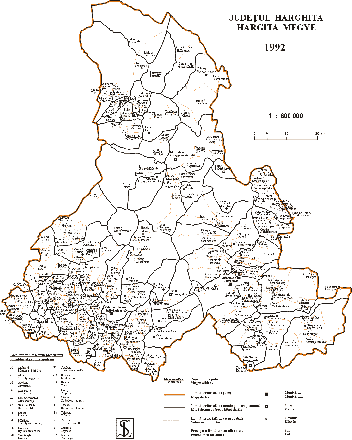
- http://sebok1.adatbank.transindex.ro/kepek/Hargita.gif
- http://sebok1.adatbank.transindex.ro/kepek/Kovaszna.gif
List of largest cities in the region:
File history
Click on a date/time to view the file as it appeared at that time.
| Date/Time | Thumbnail | Dimensions | User | Comment | |
|---|---|---|---|---|---|
| current | 17:49, 12 January 2011 | | 1,152 × 1,365 (100 KB) | PANONIAN (talk | contribs) | improved version |
| 16:57, 25 January 2008 |  | 674 × 617 (27 KB) | Walden69 (talk | contribs) | {{Information |Description= Map of Hungarians in Szekelyfold, actuallied 2002 by Andrei nacu |Source= English wikipedia en:Image:Szekely03.png |Date= 11-4-2007 |Author= Andrei nacu |Permission= {{PD-user|Andrei nacu}} |other_versions= }} [[Category:Ma |
You cannot overwrite this file.
File usage on Commons
The following 3 pages use this file:
File usage on other wikis
The following other wikis use this file:
- Usage on bg.wikipedia.org
- Usage on ca.wikipedia.org
- Usage on cy.wikipedia.org
- Usage on dsb.wikipedia.org
- Usage on en.wikipedia.org
- Usage on eo.wikipedia.org
- Usage on es.wikipedia.org
- Usage on fr.wikipedia.org
- Usage on hr.wikipedia.org
- Usage on hsb.wikipedia.org
- Usage on hu.wikipedia.org
- Usage on it.wikipedia.org
- Usage on nl.wikipedia.org
- Usage on sl.wikipedia.org
- Usage on sr.wikipedia.org