File:T.W. McKinley, printing expert of the Coast & Geodetic Survey.jpg
Original file (1,024 × 793 pixels, file size: 291 KB, MIME type: image/jpeg)
Captions
Captions
Summary edit
| Description |
English: Harris & Ewing,, photographer.
NO CAPTION [1936] 1 negative : glass ; 4 x 5 in. or smaller Notes: Date based on date of negatives in same range. Gift; Harris & Ewing, Inc. 1955. Subjects: United States. Format: Glass negatives. Rights Info: No known restrictions on publication. For more information, see Harris & Ewing Photographs - Rights and Restrictions Information www.loc.gov/rr/print/res/140_harr.html Repository: Library of Congress, Prints and Photographs Division, Washington, D.C. 20540 USA, hdl.loc.gov/loc.pnp/pp.print Part Of: Harris & Ewing photograph collection (DLC) 2009632509 General information about the Harris & Ewing Collection is available at hdl.loc.gov/loc.pnp/pp.hec Higher resolution image is available (Persistent URL): hdl.loc.gov/loc.pnp/hec.41183 Call Number: LC-H2- B-10591 |
| Date | June 29, 1936 |
| Source | https://www.flickr.com/photos/library_of_congress/52054198923/ |
| Author | The Library of Congress |

|
This image is available from the United States Library of Congress's Prints and Photographs division
under the digital ID hec.41183. This tag does not indicate the copyright status of the attached work. A normal copyright tag is still required. See Commons:Licensing.
|
Caption edit
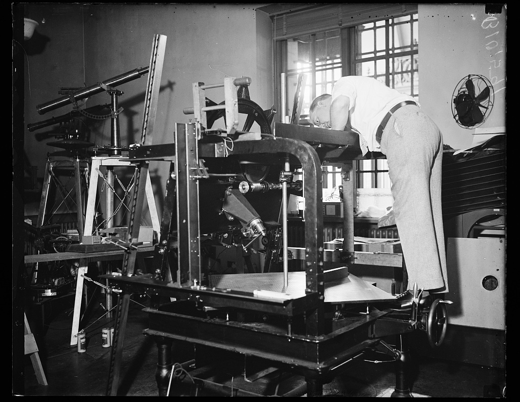
Taking Out Kinks. Washington, DC.; June 29, 1936. T.W. McKinley, printing expert of the Coast & Geodetic Survey, is testing the new printing camera devised to handle negatives made by the new nine-lens aerial camera. The printing camera lens is designed to compensate for distortion caused by the angles of the various lenses in the new mapping camera. From an altitude of 30,000 feet the new camera covers 600 square miles with one shot
Licensing edit
This image was taken from Flickr's The Commons. The uploading organization may have various reasons for determining that no known copyright restrictions exist, such as:
More information can be found at https://flickr.com/commons/usage/. Please add additional copyright tags to this image if more specific information about copyright status can be determined. See Commons:Licensing for more information. |
| This image was originally posted to Flickr by the Library of Congress at https://flickr.com/photos/8623220@N02/52054198923. It was reviewed on 2023-10-05 04:06:13 by FlickreviewR 2 and confirmed to be the same image. Library of Congress images should not be tagged with {{Flickrreview}} but with {{LOC-image}}. Images posted to Flickr are also generally of lower resolution than available from LOC directly. Please consider reuploading the image in a higher resolution from the original Library of Congress website. |
File history
Click on a date/time to view the file as it appeared at that time.
| Date/Time | Thumbnail | Dimensions | User | Comment | |
|---|---|---|---|---|---|
| current | 04:05, 5 October 2023 | | 1,024 × 793 (291 KB) | Richard Arthur Norton (1958- ) (talk | contribs) | Uploaded a work by The Library of Congress from https://www.flickr.com/photos/library_of_congress/52054198923/ with UploadWizard |
You cannot overwrite this file.
File usage on Commons
There are no pages that use this file.