File:Tabula Quinta de Asia II.png

Size of this preview: 800 × 587 pixels. Other resolutions: 320 × 235 pixels | 640 × 470 pixels | 1,024 × 751 pixels | 1,280 × 939 pixels | 2,560 × 1,879 pixels | 3,156 × 2,316 pixels.
Original file (3,156 × 2,316 pixels, file size: 15.99 MB, MIME type: image/png)
Captions
Captions
Add a one-line explanation of what this file represents
Summary edit
| Description |
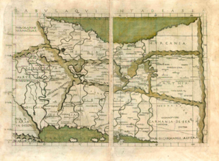
English: The 5th Map of Asia (Tabula Quinta de Asia), depicting the districts of ancient Persia, from Seven Days of Geography. Modified to obscure digital watermark from lower-res image in two places. |
| Date | |
| Source | Sanderus Maps & Own work |
| Author | Ptolemy, translated into Italian by Francesco Berlinghieri |
| Other versions |
|

Licensing edit
|
This work is in the public domain in its country of origin and other countries and areas where the copyright term is the author's life plus 70 years or fewer. This work is in the public domain in the United States because it was published (or registered with the U.S. Copyright Office) before January 1, 1929. | |
| This file has been identified as being free of known restrictions under copyright law, including all related and neighboring rights. | |
This work is based on a work in the public domain. It has been digitally enhanced and/or modified. This derivative work has been (or is hereby) released into the public domain by its author, LlywelynII. This applies worldwide.
In some countries this may not be legally possible; if so: |
File history
Click on a date/time to view the file as it appeared at that time.
| Date/Time | Thumbnail | Dimensions | User | Comment | |
|---|---|---|---|---|---|
| current | 00:03, 12 August 2016 | | 3,156 × 2,316 (15.99 MB) | LlywelynII (talk | contribs) | User created page with UploadWizard |
You cannot overwrite this file.
File usage on Commons
The following page uses this file: