File:Tarka Trail, Lambert Moor - geograph.org.uk - 71788.jpg
Size of this preview: 450 × 600 pixels. Other resolutions: 180 × 240 pixels | 480 × 640 pixels.
Original file (480 × 640 pixels, file size: 75 KB, MIME type: image/jpeg)
Captions
Captions
Add a one-line explanation of what this file represents
Summary edit
| Description |
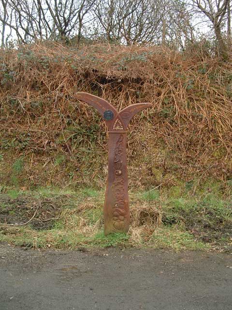
English: Tarka Trail: Lambert Moor. Half a mile past Yarde Halt SS4914, this part of the Tarka Trail reaches its highest point on the ridge between Lambert Moor and Stowford Moor. From here on it's downhill all the way!
The sign post reads: 7 MEETH SUMMIT-136METRES ACD GREAT TORRINGTON 5 1/2. NATIONAL CYCLE NETWORK 3 27. |
| Date | |
| Source | From geograph.org.uk |
| Author | Grant Sherman |
| Attribution (required by the license) | Grant Sherman / Tarka Trail: Lambert Moor / |
| Object location | | View this and other nearby images on: OpenStreetMap |
|---|
_&language=en)
Licensing edit

|
This image was taken from the Geograph project collection. See this photograph's page on the Geograph website for the photographer's contact details. The copyright on this image is owned by Grant Sherman and is licensed for reuse under the Creative Commons Attribution-ShareAlike 2.0 license.
|
This file is licensed under the Creative Commons Attribution-Share Alike 2.0 Generic license.
Attribution: Grant Sherman
- You are free:
- to share – to copy, distribute and transmit the work
- to remix – to adapt the work
- Under the following conditions:
- attribution – You must give appropriate credit, provide a link to the license, and indicate if changes were made. You may do so in any reasonable manner, but not in any way that suggests the licensor endorses you or your use.
- share alike – If you remix, transform, or build upon the material, you must distribute your contributions under the same or compatible license as the original.
File history
Click on a date/time to view the file as it appeared at that time.
| Date/Time | Thumbnail | Dimensions | User | Comment | |
|---|---|---|---|---|---|
| current | 19:42, 30 January 2010 | | 480 × 640 (75 KB) | GeographBot (talk | contribs) | == {{int:filedesc}} == {{Information |description={{en|1=Tarka Trail: Lambert Moor. Half a mile past Yarde Halt SS4914, this part of the Tarka Trail reaches its highest point on the ridge between Lambert Moor and Stowford Moor. From here on it's downh |
You cannot overwrite this file.
File usage on Commons
The following page uses this file: