File:Tatenhill Lock and Bridge near Branston, Staffordshire - geograph.org.uk - 1552927.jpg
No higher resolution available.
Tatenhill_Lock_and_Bridge_near_Branston,_Staffordshire_-_geograph.org.uk_-_1552927.jpg (640 × 471 pixels, file size: 141 KB, MIME type: image/jpeg)
Captions
Captions
Add a one-line explanation of what this file represents
Summary edit
| Description |
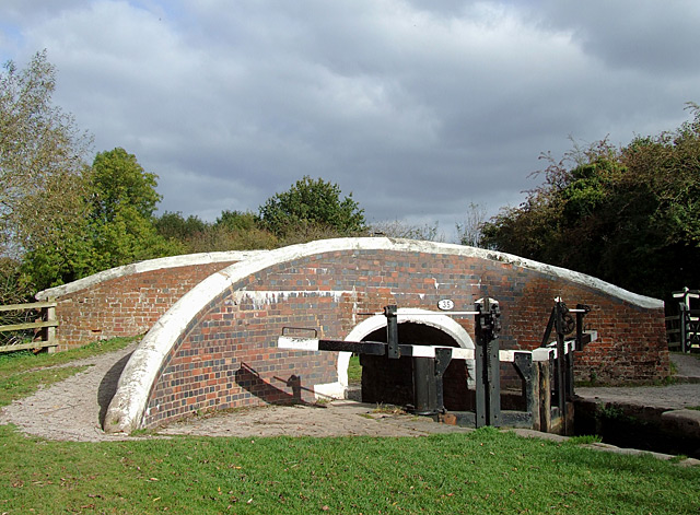
English: Tatenhill Lock and Bridge near Branston, Staffordshire. This is the Trent and Mersey Canal at Bridge No 35, which carries a bridleway. The bottom mitre gates of Tatenhill Lock can be seen. This is not a deep lock, dropping the water level by just over one metre (3ft 7in). The Way for the Millennium, Staffordshire's extensive long distance public footpath, follows the towpath here. http://www.staffordshire.gov.uk/environment/e-land/RightsofWay/PromotedRoutes/ROWPromotedRouteMillennium.htm The several lakes comprising Branston Water Park behind the trees are former sand and gravel pits, of which there are many in the area. |
| Date | |
| Source | From geograph.org.uk |
| Author | Roger Kidd |
| Attribution (required by the license) | Roger Kidd / Tatenhill Lock and Bridge near Branston, Staffordshire / |
| Camera location | | View this and other nearby images on: OpenStreetMap |
|---|
_heading:67.00&language=en)
| Object location | | View this and other nearby images on: OpenStreetMap |
|---|
_heading:67.00&language=en)
Licensing edit

|
This image was taken from the Geograph project collection. See this photograph's page on the Geograph website for the photographer's contact details. The copyright on this image is owned by Roger Kidd and is licensed for reuse under the Creative Commons Attribution-ShareAlike 2.0 license.
|
This file is licensed under the Creative Commons Attribution-Share Alike 2.0 Generic license.
Attribution: Roger Kidd
- You are free:
- to share – to copy, distribute and transmit the work
- to remix – to adapt the work
- Under the following conditions:
- attribution – You must give appropriate credit, provide a link to the license, and indicate if changes were made. You may do so in any reasonable manner, but not in any way that suggests the licensor endorses you or your use.
- share alike – If you remix, transform, or build upon the material, you must distribute your contributions under the same or compatible license as the original.
File history
Click on a date/time to view the file as it appeared at that time.
| Date/Time | Thumbnail | Dimensions | User | Comment | |
|---|---|---|---|---|---|
| current | 14:37, 3 March 2011 | | 640 × 471 (141 KB) | GeographBot (talk | contribs) | == {{int:filedesc}} == {{Information |description={{en|1=Tatenhill Lock and Bridge near Branston, Staffordshire This is the Trent and Mersey Canal at Bridge No 35, which carries a bridleway. The bottom mitre gates of Tatenhill Lock can be seen. This is no |
You cannot overwrite this file.
File usage on Commons
There are no pages that use this file.
File usage on other wikis
The following other wikis use this file:
- Usage on en.wikipedia.org