File:Taurus-gebirge.jpg

Size of this preview: 800 × 397 pixels. Other resolutions: 320 × 159 pixels | 640 × 317 pixels | 1,024 × 508 pixels | 1,600 × 793 pixels.
Original file (1,600 × 793 pixels, file size: 443 KB, MIME type: image/jpeg)
Captions
Captions
Add a one-line explanation of what this file represents
Summary edit
| Description |
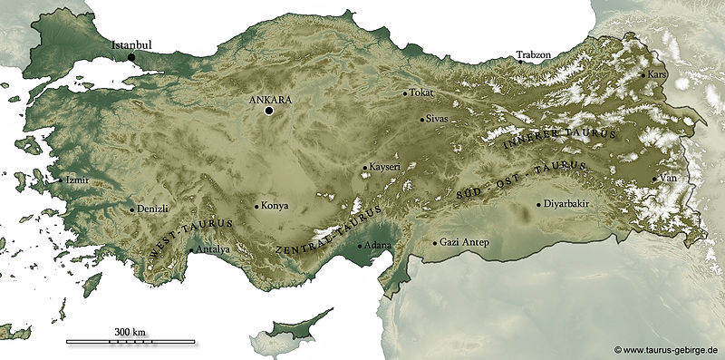
Deutsch: Reliefkarte (SRTM GTOPO30) |
| Date | |
| Source | http://www.taurus-gebirge.de/taurusgebirge |
| Author | MartinMAP at German Wikipedia |
| Permission (Reusing this file) |
|
| Other versions |
|

Licensing edit
MartinMAP at German Wikipedia, the copyright holder of this work, hereby publishes it under the following licenses:

|
Permission is granted to copy, distribute and/or modify this document under the terms of the GNU Free Documentation License, Version 1.2 or any later version published by the Free Software Foundation; with no Invariant Sections, no Front-Cover Texts, and no Back-Cover Texts. A copy of the license is included in the section entitled GNU Free Documentation License. |
This file is licensed under the Creative Commons Attribution-Share Alike 3.0 Unported license.
Attribution: MartinMAP at German Wikipedia
- You are free:
- to share – to copy, distribute and transmit the work
- to remix – to adapt the work
- Under the following conditions:
- attribution – You must give appropriate credit, provide a link to the license, and indicate if changes were made. You may do so in any reasonable manner, but not in any way that suggests the licensor endorses you or your use.
- share alike – If you remix, transform, or build upon the material, you must distribute your contributions under the same or compatible license as the original.
This file is licensed under the Creative Commons Attribution-Share Alike 3.0 Germany license.
Attribution: MartinMAP at German Wikipedia
- You are free:
- to share – to copy, distribute and transmit the work
- to remix – to adapt the work
- Under the following conditions:
- attribution – You must give appropriate credit, provide a link to the license, and indicate if changes were made. You may do so in any reasonable manner, but not in any way that suggests the licensor endorses you or your use.
- share alike – If you remix, transform, or build upon the material, you must distribute your contributions under the same or compatible license as the original.

You may select the license of your choice.
Original upload log edit
Transferred from de.wikipedia to Commons by Brackenheim using CommonsHelper.
The original description page was here. All following user names refer to de.wikipedia.
- 2011-03-11 08:37 MartinMAP 1600×793× (453422 bytes) {{Information |Beschreibung = Die Türkei mit Gliederung des Taurusgabirges |Quelle = www.taurus-gebirge.de |Urheber = ~~~ - www.taurus-gabirge.de |Datum = Marburg, 11.03.2011 |Genehmigung = |Andere Versionen = |An
- 2010-12-11 17:09 MartinMAP 943×542× (330061 bytes) Zurückgesetzt auf die Version vom 11. Dezember 2010, 17:05 Uhr
- 2010-12-11 17:08 MartinMAP 943×542× (330061 bytes) Zurückgesetzt auf die Version vom 11. Dezember 2010, 17:05 Uhr
- 2010-12-11 17:08 MartinMAP 943×542× (330061 bytes) {{Information |Beschreibung = |Quelle = |Urheber = |Datum = |Genehmigung = |Andere Versionen = |Anmerkungen = }}
- 2010-12-11 17:06 MartinMAP 943×542× (310420 bytes) Zurückgesetzt auf die Version vom 18. Oktober 2010, 14:21 Uhr
- 2010-12-11 17:05 MartinMAP 943×542× (330061 bytes) {{Information |Beschreibung = |Quelle = |Urheber = |Datum = |Genehmigung = |Andere Versionen = |Anmerkungen = }}
- 2010-10-18 14:21 MartinMAP 943×542× (310420 bytes) {{Information |Beschreibung = Übersichtskarte mit Beschriftung der Teile des Taurusgebirges |Quelle = http://www2.jpl.nasa.gov/srtm/ |Urheber = ~~~ |Datum = 16.10.2010 |Genehmigung = |Andere Versionen = |Anmerkungen = SRTM DEM-Daten + Beschriftung nach
File history
Click on a date/time to view the file as it appeared at that time.
| Date/Time | Thumbnail | Dimensions | User | Comment | |
|---|---|---|---|---|---|
| current | 10:03, 9 April 2011 | | 1,600 × 793 (443 KB) | File Upload Bot (Magnus Manske) (talk | contribs) | {{BotMoveToCommons|de.wikipedia|year={{subst:CURRENTYEAR}}|month={{subst:CURRENTMONTHNAME}}|day={{subst:CURRENTDAY}}}} {{Information |Description={{de|Reliefkarte (SRTM GTOPO30)}} |Source=Transferred from [http://de.wikipedia.org de.wikipedia]; transferr |
You cannot overwrite this file.
File usage on Commons
The following page uses this file:
File usage on other wikis
The following other wikis use this file:
- Usage on de.wikipedia.org