File:Tcdd network.png
Size of this preview: 800 × 368 pixels. Other resolutions: 320 × 147 pixels | 640 × 294 pixels | 1,024 × 471 pixels | 1,280 × 588 pixels | 3,539 × 1,627 pixels.
Original file (3,539 × 1,627 pixels, file size: 867 KB, MIME type: image/png)
Captions
Captions
Add a one-line explanation of what this file represents
source: http://en.wikipedia.org/wiki/Image:Tcdd_network.png

|
File:TCDD.svg is a vector version of this file. It should be used in place of this PNG file when not inferior.
File:Tcdd network.png → File:TCDD.svg
For more information, see Help:SVG. |
 |
Summary edit
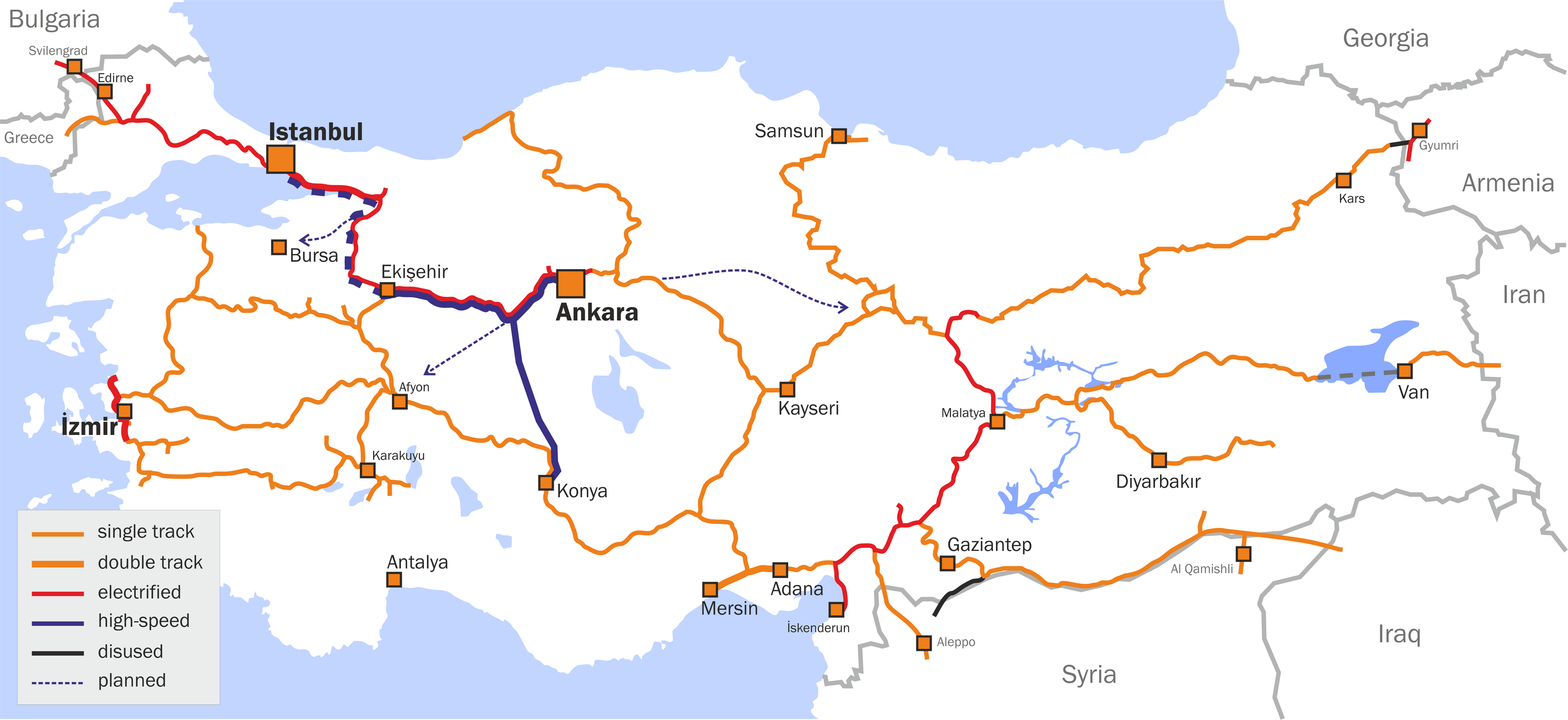
Turkish State Railways network map
Licensing edit
I, the copyright holder of this work, hereby publish it under the following license:
| This file is licensed under the Creative Commons Attribution-Share Alike 3.0 Unported license. Subject to disclaimers. | ||
| ||
| This licensing tag was added to this file as part of the GFDL licensing update. |

|
Permission is granted to copy, distribute and/or modify this document under the terms of the GNU Free Documentation License, Version 1.2 or any later version published by the Free Software Foundation; with no Invariant Sections, no Front-Cover Texts, and no Back-Cover Texts. A copy of the license is included in the section entitled GNU Free Documentation License. Subject to disclaimers. |
18 April 2007
File history
Click on a date/time to view the file as it appeared at that time.
| Date/Time | Thumbnail | Dimensions | User | Comment | |
|---|---|---|---|---|---|
| current | 23:11, 8 March 2015 | | 3,539 × 1,627 (867 KB) | Denniss (talk | contribs) | Reverted to version as of 10:39, 25 September 2012 |
| 16:32, 13 February 2015 |  | 800 × 368 (158 KB) | Saetab2 (talk | contribs) | {{Information |Description= |Source= |Date= |Author=yapanın kendi çalışması |Permission= |other_versions= }} | |
| 10:39, 25 September 2012 |  | 3,539 × 1,627 (867 KB) | Classical geographer (talk | contribs) | Smaller version. | |
| 10:31, 25 September 2012 |  | 11,797 × 5,424 (1.95 MB) | Classical geographer (talk | contribs) | Remade the map, using File:TCDD System Map.GIF as a base, and [http://www.bueker.net/trainspotting/map.php?file=maps/turkey/turkey.gif this map] as an excellent secondary source. Note that there is also File:YHT Turkey 1200x675.png with a rat... | |
| 13:33, 12 September 2007 |  | 1,045 × 611 (456 KB) | Ori~ (talk | contribs) | source: http://en.wikipedia.org/wiki/Image:Tcdd_network.png == Summary == Turkish State Railways network map == Licensing == {{GFDL-self-with-disclaimers}} 18 April 2007 en:User:System Halted |
You cannot overwrite this file.
File usage on Commons
The following 8 pages use this file:
- User:Chumwa/OgreBot/Public transport information/2015 February 10-18
- User:Chumwa/OgreBot/Public transport information/2015 March 1-10
- User:Chumwa/OgreBot/Transport Maps/2015 February 10-18
- User:Chumwa/OgreBot/Transport Maps/2015 March 1-10
- User:Liesel/Rail transport/2015 February 10-18
- Commons:Graphic Lab/Illustration workshop/Archive/2022
- Commons:Graphic Lab/Map workshop/Archive/2022
- File:TCDD.svg
File usage on other wikis
The following other wikis use this file:
- Usage on it.wikinews.org