File:Teltower Kreisbahnen Netzplan.png
Size of this preview: 800 × 323 pixels. Other resolutions: 320 × 129 pixels | 640 × 258 pixels | 1,024 × 413 pixels | 1,280 × 517 pixels | 2,560 × 1,034 pixels | 5,917 × 2,389 pixels.
Original file (5,917 × 2,389 pixels, file size: 9.82 MB, MIME type: image/png)
Captions
Captions
Add a one-line explanation of what this file represents
Summary edit
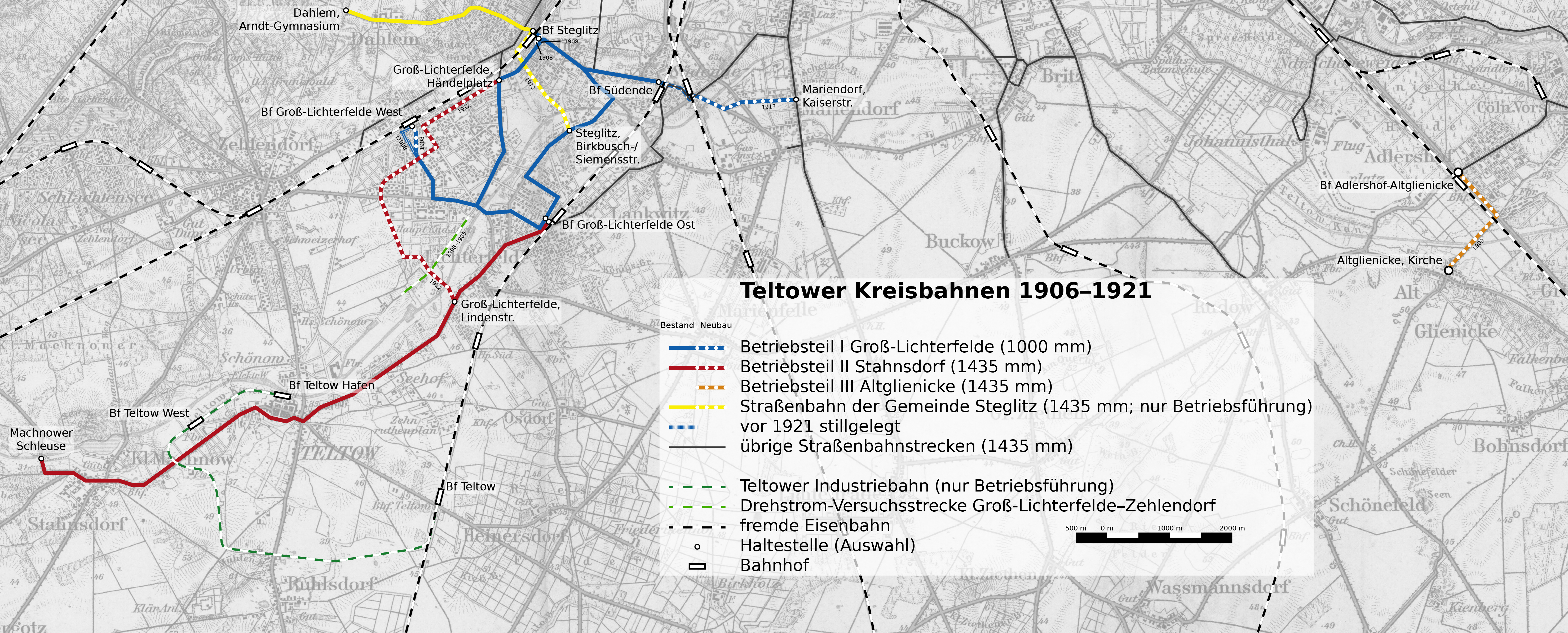
| Description | Streckenkarte der Teltower Kreisbahnen 1906–1921 |
| Date | |
| Source | Eigenes Werk, basierend auf File:Karte der Umgebung von Berlin 100K 1912.jpg |
| Author | Christian Liebscher |
Licensing edit
I, the copyright holder of this work, hereby publish it under the following license:
This file is licensed under the Creative Commons Attribution 4.0 International license.
- You are free:
- to share – to copy, distribute and transmit the work
- to remix – to adapt the work
- Under the following conditions:
- attribution – You must give appropriate credit, provide a link to the license, and indicate if changes were made. You may do so in any reasonable manner, but not in any way that suggests the licensor endorses you or your use.
File history
Click on a date/time to view the file as it appeared at that time.
| Date/Time | Thumbnail | Dimensions | User | Comment | |
|---|---|---|---|---|---|
| current | 17:33, 11 March 2023 | 5,917 × 2,389 (9.82 MB) | Platte (talk | contribs) | Aufnahme Drehstrom-Versuchsstrecke Groß-Lichterfelde–Zehlendorf | |
| 03:39, 6 January 2022 | 5,969 × 2,446 (9.83 MB) | Platte (talk | contribs) | Streckenführung korr. | ||
| 15:28, 2 January 2022 | 5,917 × 2,389 (9.8 MB) | Platte (talk | contribs) | cropped | ||
| 14:55, 2 January 2022 | 5,969 × 2,446 (9.83 MB) | Platte (talk | contribs) | {{Information |Description=Streckenkarte der Teltower Kreisbahnen 1906–1921 |Source=Eigenes Werk, basierend auf File:Karte der Umgebung von Berlin 100K 1912.jpg |Date=2022-01-02 |Author= Platte |Permission= |other_versions= }} Category:Tram maps of Berlin Category:Maps of Landkreis Potsdam-Mittelmark Category:Maps of Treptow-Köpenick Category:Maps of Steglitz-Zehlendorf Category:Maps of Tempelhof-Schöneberg Category:Images by User:Platte |
You cannot overwrite this file.
File usage on Commons
The following 6 pages use this file:
- User:Chumwa/OgreBot/Public transport information/2022 January 1-10
- User:Chumwa/OgreBot/Public transport information/2023 March 11-20
- User:Chumwa/OgreBot/Transport Maps/2022 January 1-10
- User:Chumwa/OgreBot/Transport Maps/2023 March 11-20
- User:Jcornelius/Berlin rail transport/2023 March 11-20
- User:Platte/Rail transport Berlin/2023 March
File usage on other wikis
The following other wikis use this file: