File:Tenmile Fletcher Group.jpg

Size of this preview: 800 × 530 pixels. Other resolutions: 320 × 212 pixels | 640 × 424 pixels.
Original file (906 × 600 pixels, file size: 408 KB, MIME type: image/jpeg)
Captions
Captions
Add a one-line explanation of what this file represents
Summary
edit
| Description |
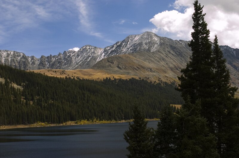
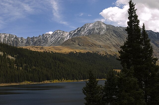
English: View of the Fletcher Group of the Tenmile Range off of State Highway 91 North of Leadville. The mountain that looks largest is "Drift Peak" the quotations are because it is unnamed on many maps, it has an unofficial elevation of 13,900 feet, and is charactorized by its double humped peak. Fletcher Mountain is the next largest peak to the left, although it is taller than "Drift Peak" with an elevation of 13,951. It is only smaller than Quandary Peak in the Tenmile Range. Clinton Resevoir is in the foreground. |
| Date | |
| Source | Own work |
| Author | Wayne L. Bart |
Licensing
edit
This file is licensed under the Creative Commons Attribution-Share Alike 2.5 Generic license.
- You are free:
- to share – to copy, distribute and transmit the work
- to remix – to adapt the work
- Under the following conditions:
- attribution – You must give appropriate credit, provide a link to the license, and indicate if changes were made. You may do so in any reasonable manner, but not in any way that suggests the licensor endorses you or your use.
- share alike – If you remix, transform, or build upon the material, you must distribute your contributions under the same or compatible license as the original.
Original upload log
edit
Transferred from en.wikipedia to Commons by Xnatedawgx using CommonsHelper.
The original description page was here. All following user names refer to en.wikipedia.
- 2006-03-10 05:13 Throughthelens 906×600× (417756 bytes) {{Information| |Description = View of the Fletcher Group of the [[Tenmile Range]] off of [[Colorado Route 91]] North of [[Leadville, Colorado|Leadville]]. The mountain that looks largest is "Drift Peak" the quotations are because it is unnamed on many ma
File history
Click on a date/time to view the file as it appeared at that time.
| Date/Time | Thumbnail | Dimensions | User | Comment | |
|---|---|---|---|---|---|
| current | 21:53, 2 May 2011 | | 906 × 600 (408 KB) | File Upload Bot (Magnus Manske) (talk | contribs) | {{BotMoveToCommons|en.wikipedia|year={{subst:CURRENTYEAR}}|month={{subst:CURRENTMONTHNAME}}|day={{subst:CURRENTDAY}}}} {{Information |Description={{en|View of the Fletcher Group of the en:Tenmile Range off of [[:en:Colorado State Highway 91|State H |
You cannot overwrite this file.
File usage on Commons
The following page uses this file:
File usage on other wikis
The following other wikis use this file:
- Usage on ceb.wikipedia.org
- Usage on el.wikipedia.org
- Usage on en.wikipedia.org
- Usage on ga.wikipedia.org
- Usage on ja.wikipedia.org
- Usage on www.wikidata.org