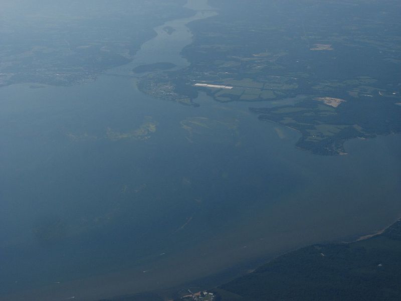
File:Terminus of Chesapeake Bay and Mouth of Susquehanna River (2894725268).jpg

Original file (1,280 × 960 pixels, file size: 68 KB, MIME type: image/jpeg)
Captions
Captions
Summary edit
| DescriptionTerminus of Chesapeake Bay and Mouth of Susquehanna River (2894725268).jpg |
The Susquehanna River is a river located in the northeastern United States. At 464 miles (747 km) long, it is the longest river on the American east coast that drains into the Atlantic Ocean, and with its watershed it is the 16th largest river in the United States, and the longest river in the continental United States without commercial boat traffic today—for what navigations had been used to improve the waterway for barge shipping of bulk goods by water transport of the Pennsylvania Canal in the Canal Era were let go under the domination of the more flexible and much faster shipping measures under the railroad industry. The nation's sixteenth largest river by volume, the Susquehanna flows through New York, Pennsylvania, and Maryland into the Chesapeake Bay. It forms from two main branches, with the "North Branch", which rises in upstate New York, regarded by federal mapmakers as the main branch, and the West Branch Susquehanna, both of which were improved by navigations in the 1820s—1830s as the Pennsylvania Canal which, using the offices of the Allegheny Portage Railroad actually allowed ladened barges to be hoisted across the mountain ridge into the Pittsburgh area. The 82 mile leg conceived to connect the Delaware to the Susquehanna became instead the Philadelphia and Columbia Railroad built by the Pennsylvania Canal Commission. The shorter West Branch, which rises in western Pennsylvania, joins the main stem near Northumberland in central Pennsylvania. The river drains 27,500 square miles (71,000 km2), including nearly half of the land area of Pennsylvania. The drainage basin (watershed) includes portions of the Allegheny Plateau region of the Appalachian Mountains, cutting through a succession of water gaps in a broad zigzag course to flow across the rural heartland of southeastern Pennsylvania and northeastern Maryland in the lateral near-parallel array of mountain ridges. The river empties into the northern end of the Chesapeake Bay at Havre de Grace, Maryland, providing half of the Bay's freshwater inflow. The Chesapeake Bay is in fact the ria of the Susquehanna. en.wikipedia.org/wiki/Susquehanna_River en.wikipedia.org/wiki/Wikipedia:Text_of_Creative_Commons_... |
| Date | |
| Source | Terminus of Chesapeake Bay and Mouth of Susquehanna River |
| Author | Ken Lund from Reno, Nevada, USA |
| Camera location | 39° 33′ 09.24″ N, 76° 04′ 59.04″ W | View this and other nearby images on: OpenStreetMap |
|---|
Licensing edit
- You are free:
- to share – to copy, distribute and transmit the work
- to remix – to adapt the work
- Under the following conditions:
- attribution – You must give appropriate credit, provide a link to the license, and indicate if changes were made. You may do so in any reasonable manner, but not in any way that suggests the licensor endorses you or your use.
- share alike – If you remix, transform, or build upon the material, you must distribute your contributions under the same or compatible license as the original.
| This image was originally posted to Flickr by Ken Lund at https://flickr.com/photos/75683070@N00/2894725268. It was reviewed on 3 December 2015 by FlickreviewR and was confirmed to be licensed under the terms of the cc-by-sa-2.0. |
3 December 2015
File history
Click on a date/time to view the file as it appeared at that time.
| Date/Time | Thumbnail | Dimensions | User | Comment | |
|---|---|---|---|---|---|
| current | 22:03, 3 December 2015 |  | 1,280 × 960 (68 KB) | INeverCry (talk | contribs) | Transferred from Flickr via Flickr2Commons |
You cannot overwrite this file.
File usage on Commons
There are no pages that use this file.
Metadata
This file contains additional information such as Exif metadata which may have been added by the digital camera, scanner, or software program used to create or digitize it. If the file has been modified from its original state, some details such as the timestamp may not fully reflect those of the original file. The timestamp is only as accurate as the clock in the camera, and it may be completely wrong.
| Camera manufacturer | Canon |
|---|---|
| Camera model | Canon PowerShot A540 |
| Exposure time | 1/1,250 sec (0.0008) |
| F-number | f/4 |
| Date and time of data generation | 13:35, 1 August 2008 |
| Lens focal length | 9.817 mm |
| Orientation | Normal |
| Horizontal resolution | 180 dpi |
| Vertical resolution | 180 dpi |
| File change date and time | 13:35, 1 August 2008 |
| Y and C positioning | Centered |
| Exif version | 2.2 |
| Date and time of digitizing | 13:35, 1 August 2008 |
| Meaning of each component |
|
| Image compression mode | 5 |
| APEX shutter speed | 10.28125 |
| APEX aperture | 4 |
| APEX exposure bias | −0.66666666666667 |
| Maximum land aperture | 3.625 APEX (f/3.51) |
| Metering mode | Pattern |
| Flash | Flash did not fire, compulsory flash suppression, red-eye reduction mode |
| Supported Flashpix version | 1 |
| Color space | sRGB |
| Focal plane X resolution | 10,097.777777778 |
| Focal plane Y resolution | 10,082.840236686 |
| Focal plane resolution unit | inches |
| Sensing method | One-chip color area sensor |
| File source | Digital still camera |
| Custom image processing | Normal process |
| Exposure mode | Manual exposure |
| White balance | Auto white balance |
| Digital zoom ratio | 1 |
| Scene capture type | Landscape |