File:Tern-Stuttgart-Project.jpg
Tern-Stuttgart-Project.jpg (800 × 586 pixels, file size: 190 KB, MIME type: image/jpeg)
File information
Structured data
Captions
Summary edit
DescriptionTern-Stuttgart-Project.jpg |
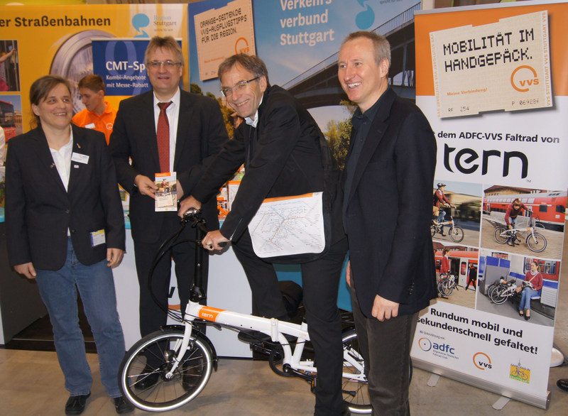
English: Tern-VVS Stuttgart transport project presentation display. (L to R): Gudrun Zühlke (ADFC Baden-Württemberg), Thomas Hachenberger (CEO VVS), Werner Wölfle (Green, Administrative Mayor of Stuttgart), Horst Stammler (Geschäftsführer VVS) |
Date | |
Source | Own work |
Author | Ermah |
Camera location | 51° 31′ 08.3″ N, 0° 06′ 04.01″ W | View this and other nearby images on: OpenStreetMap | 51.518973; -0.101115 |
---|
Licensing edit
I, the copyright holder of this work, hereby publish it under the following license:
This file is licensed under the Creative Commons Attribution-Share Alike 3.0 Unported license.
- You are free:
- to share – to copy, distribute and transmit the work
- to remix – to adapt the work
- Under the following conditions:
- attribution – You must give appropriate credit, provide a link to the license, and indicate if changes were made. You may do so in any reasonable manner, but not in any way that suggests the licensor endorses you or your use.
- share alike – If you remix, transform, or build upon the material, you must distribute your contributions under the same or compatible license as the original.
File history
Click on a date/time to view the file as it appeared at that time.
Date/Time | Thumbnail | Dimensions | User | Comment | |
---|---|---|---|---|---|
current | 10:07, 3 April 2013 | 800 × 586 (190 KB) | Ermah (talk | contribs) | User created page with UploadWizard |
You cannot overwrite this file.
File usage on Commons
There are no pages that use this file.
Metadata
This file contains additional information such as Exif metadata which may have been added by the digital camera, scanner, or software program used to create or digitize it. If the file has been modified from its original state, some details such as the timestamp may not fully reflect those of the original file. The timestamp is only as accurate as the clock in the camera, and it may be completely wrong.
Image title |
|
---|---|
Camera manufacturer | SONY |
Camera model | SLT-A55V |
Author | Picasa |
Exposure time | 1/60 sec (0.016666666666667) |
F-number | f/5 |
ISO speed rating | 400 |
Date and time of data generation | 11:50, 12 January 2013 |
Lens focal length | 18 mm |
Latitude | 51° 31′ 8.3″ N |
Longitude | 0° 6′ 4.01″ W |
Altitude | 22.4 meters above sea level |
Horizontal resolution | 350 dpi |
Vertical resolution | 350 dpi |
Software used | Adobe Photoshop 7.0 |
File change date and time | 18:00, 3 April 2013 |
Y and C positioning | Co-sited |
Exposure Program | Normal program |
Exif version | 2.3 |
Date and time of digitizing | 11:50, 12 January 2013 |
Meaning of each component |
|
Image compression mode | 2 |
APEX brightness | 1.87 |
APEX exposure bias | 0 |
Maximum land aperture | 3.61 APEX (f/3.49) |
Metering mode | Pattern |
Light source | Unknown |
Flash | Flash fired, compulsory flash firing |
Supported Flashpix version | 1 |
Color space | Uncalibrated |
File source | Digital still camera |
Scene type | A directly photographed image |
Custom image processing | Normal process |
Exposure mode | Auto exposure |
White balance | Auto white balance |
Focal length in 35 mm film | 27 mm |
Scene capture type | Standard |
Contrast | Normal |
Saturation | Normal |
Sharpness | Normal |
Unique image ID | 417bc21692829e184109f3e65ff2f005 |
GPS time (atomic clock) | 21:36 |
Receiver status | Measurement interoperability |
Measurement mode | 3-dimensional measurement |
Speed unit | Kilometers per hour |
Speed of GPS receiver | 0.7 |
Reference for direction of movement | True direction |
Direction of movement | 86.77 |
Geodetic survey data used | WGS-84 |
GPS date | 9 June 2012 |
GPS differential correction | 0 |
GPS tag version | 0.0.3.2 |
IIM version | 4 |