File:Territory of the United States from the Mississippi River to the Pacific Ocean; originally prepared to accompany the reports of the explorations for a Pacific railroad route. LOC gm71000836.tif

Size of this JPG preview of this TIF file: 653 × 599 pixels. Other resolutions: 262 × 240 pixels | 523 × 480 pixels | 837 × 768 pixels | 1,116 × 1,024 pixels | 2,231 × 2,048 pixels | 14,886 × 13,664 pixels.
Original file (14,886 × 13,664 pixels, file size: 581.94 MB, MIME type: image/tiff)
Captions
Captions
Add a one-line explanation of what this file represents
Summary edit
| Warning | The original file is very high-resolution. It might not load properly or could cause your browser to freeze when opened at full size. |
|---|
| Description |
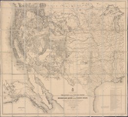
English: Scale 1:3,000,000. Relief shown by hachures and spot heights. LC copy sectioned and mounted on cloth backing. Annotated on verso: United States from the Mississippi to the Pacific Ocean. 1868. Millard Fillmore, Nov. 17, 1869. Shows routes and dates of expeditions and surveys. Includes list of "Authorities" and inset "Territory of Alaska." Available also through the Library of Congress Web site as a raster image. Vault AACR2 |
||
| Title | Territory of the United States from the Mississippi River to the Pacific Ocean; originally prepared to accompany the reports of the explorations for a Pacific railroad route. | ||
| Shelf ID | G4050 1868 .F7 | ||
| Date | |||
| Source | https://www.loc.gov/item/gm71000836/ | ||
| Author | Freyhold, Edward; Warren, G. K. (Gouverneur Kemble); Bien, Julius; United States. War Department | ||
| Permission (Reusing this file) |
|
||
| Other versions |
|
||
| Location | United States · West · West. | ||
| Part of | American Memory · General Maps · Catalog · Transportation And Communication · Geography And Map Division | ||
| Subject | Pacific Railroads · Railroads · Explorations And Surveys · West (U.S.) · United States · Maps · West |


Licensing edit
|
This is a faithful photographic reproduction of a two-dimensional, public domain work of art. The work of art itself is in the public domain for the following reason:
The official position taken by the Wikimedia Foundation is that "faithful reproductions of two-dimensional public domain works of art are public domain".
This photographic reproduction is therefore also considered to be in the public domain in the United States. In other jurisdictions, re-use of this content may be restricted; see Reuse of PD-Art photographs for details. | ||||
File history
Click on a date/time to view the file as it appeared at that time.
| Date/Time | Thumbnail | Dimensions | User | Comment | |
|---|---|---|---|---|---|
| current | 02:22, 11 June 2018 |  | 14,886 × 13,664 (581.94 MB) | Fæ (talk | contribs) | LOC Maps https://www.loc.gov/item/gm71000836/ #11290 |
You cannot overwrite this file.
File usage on Commons
The following page uses this file: