File:Texaco Road and Texaco Road North Map.png

Size of this preview: 556 × 599 pixels. Other resolutions: 223 × 240 pixels | 445 × 480 pixels | 770 × 830 pixels.
Original file (770 × 830 pixels, file size: 1,022 KB, MIME type: image/png)
Captions
Captions
Add a one-line explanation of what this file represents
Summary edit
| Description |
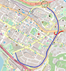
中文(香港):德士古道及德士古道北地圖,走綫以藍色表示(德士古交匯處以紅色表示)。 |
| Date | |
| Source | https://www.openstreetmap.org/#map=16/22.3695/114.1161 |
| Author | OpenStreetMap contributors |
Licensing edit
| This work contains information from OpenStreetMap, which is made available under the Open Database License (ODbL).
The ODbL does not require any particular license for maps produced from ODbL data. Prior to 1 August 2020, map tiles produced by the OpenStreetMap Foundation were licensed under the CC-BY-SA-2.0 license. Maps produced by other people may be subject to other licences. |
File history
Click on a date/time to view the file as it appeared at that time.
| Date/Time | Thumbnail | Dimensions | User | Comment | |
|---|---|---|---|---|---|
| current | 11:30, 3 May 2020 | | 770 × 830 (1,022 KB) | Sanmosa (talk | contribs) | Add Texaco Interchange |
| 11:54, 1 May 2020 |  | 770 × 830 (1,023 KB) | Sanmosa (talk | contribs) | Uploaded a work by OpenStreetMap contributors from https://www.openstreetmap.org/#map=16/22.3695/114.1161 with UploadWizard |
You cannot overwrite this file.
File usage on Commons
There are no pages that use this file.
File usage on other wikis
The following other wikis use this file:
- Usage on zh.wikipedia.org