File:Texas Mexico Disputed Border 1836 to 1848.PNG
No higher resolution available.
Texas_Mexico_Disputed_Border_1836_to_1848.PNG (460 × 521 pixels, file size: 46 KB, MIME type: image/png)
Captions
Captions
Add a one-line explanation of what this file represents

|
This historical map image could be re-created using vector graphics as an SVG file. This has several advantages; see Commons:Media for cleanup for more information. If an SVG form of this image is available, please upload it and afterwards replace this template with
{{vector version available|new image name}}.
It is recommended to name the SVG file “Texas Mexico Disputed Border 1836 to 1848.svg”—then the template Vector version available (or Vva) does not need the new image name parameter. |
Summary edit
this is the new PNG version of the file originally submitted by w:User:ChuchoHuff
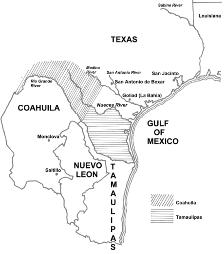
English: The Republic of the Rio Grande claimed the above areas, which are the previous boundaries for the Mexican states of w:Coahuila and w:Tamaulipas. The Republic of Texas claimed its southern border was the Río Grande, people living immediately north of the Río Grande still thought of themselves as Mexicans. In the minds of those at the Constitutional Convention near Laredo, the northern border of Tamaulipas was with the w:Nueces River and the northern border of Coahuila was with the upper w:Medina River. This area of land south to the Río Grande was already in dispute of ownership between the Republic of Texas and México. And as of January 1840, the Republic of the Río Grande was laying a third claim to the area.
original image was from [original link: http://www.tamu.edu/ccbn/dewitt/co&tex1836.htm#currtex]
permission released by The Sons of DeWitt Colony Texas, Wallace L. McKeehan, ed. to the original uploader of file
Licensing edit
This file is licensed under the Creative Commons Attribution-Share Alike 2.5 Generic license.
Attribution: http://www.tamu.edu/ccbn/dewitt/co&tex1836.htm#currtex is cited as the original source of the edited uploaded material, uploaded for use in the w:Republic of the Rio Grande
- You are free:
- to share – to copy, distribute and transmit the work
- to remix – to adapt the work
- Under the following conditions:
- attribution – You must give appropriate credit, provide a link to the license, and indicate if changes were made. You may do so in any reasonable manner, but not in any way that suggests the licensor endorses you or your use.
- share alike – If you remix, transform, or build upon the material, you must distribute your contributions under the same or compatible license as the original.
File history
Click on a date/time to view the file as it appeared at that time.
| Date/Time | Thumbnail | Dimensions | User | Comment | |
|---|---|---|---|---|---|
| current | 20:12, 7 January 2007 | | 460 × 521 (46 KB) | Muaddeeb (talk | contribs) | <small>this is the new PNG version of the file originally submitted by User:ChuchoHuff </small> The Republic of the Rio Grande claimed the above areas, which are the previous boundaries for the Mexican states of Coahuila and Tamaulipas. The R |
| 20:06, 7 January 2007 |  | 460 × 521 (46 KB) | Muaddeeb (talk | contribs) | <small>this is the new PNG version of the file originally submitted by User:ChuchoHuff </small> The Republic of the Rio Grande claimed the above areas, which are the previous boundaries for the Mexican states of Coahuila and Tamaulipas. The R |
You cannot overwrite this file.
File usage on Commons
There are no pages that use this file.
File usage on other wikis
The following other wikis use this file:
- Usage on en.wikipedia.org
- Usage on mk.wikipedia.org