File:Texas Presidential Election Results 1972.svg

Size of this PNG preview of this SVG file: 631 × 599 pixels. Other resolutions: 253 × 240 pixels | 506 × 480 pixels | 809 × 768 pixels | 1,079 × 1,024 pixels | 2,157 × 2,048 pixels | 810 × 769 pixels.
Original file (SVG file, nominally 810 × 769 pixels, file size: 104 KB)
Captions
Captions
Add a one-line explanation of what this file represents
Summary edit
| Description |
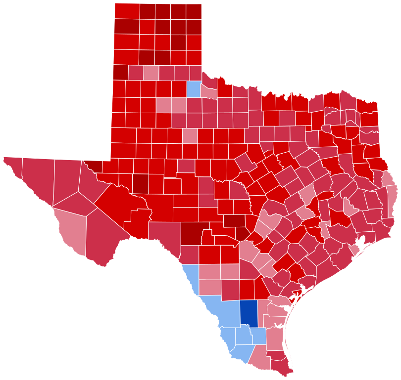
English: United States presidential election in Texas, 1972 results by county
Nixon 50-59%
60-69%
70-79%
80-89%
McGovern 50-56%
80-89% |
| Date | |
| Source | Shapes derived from Republican Party presidential primaries results by county, 2016, colored in by Mr.Election |
| Author | Mr.Election |
Licensing edit
I, the copyright holder of this work, hereby publish it under the following license:
This file is licensed under the Creative Commons Attribution-Share Alike 4.0 International license.
- You are free:
- to share – to copy, distribute and transmit the work
- to remix – to adapt the work
- Under the following conditions:
- attribution – You must give appropriate credit, provide a link to the license, and indicate if changes were made. You may do so in any reasonable manner, but not in any way that suggests the licensor endorses you or your use.
- share alike – If you remix, transform, or build upon the material, you must distribute your contributions under the same or compatible license as the original.
File history
Click on a date/time to view the file as it appeared at that time.
| Date/Time | Thumbnail | Dimensions | User | Comment | |
|---|---|---|---|---|---|
| current | 23:15, 29 February 2024 | | 810 × 769 (104 KB) | Putitonamap98 (talk | contribs) | shapes county lines of two costal counties were different pre 1975 |
| 00:23, 1 June 2023 |  | 810 × 769 (104 KB) | CrookCoMaps61 (talk | contribs) | Shapes | |
| 11:07, 30 May 2023 |  | 344 × 336 (55 KB) | Tinpo162 (talk | contribs) | Reverted to version as of 05:15, 8 July 2020 (UTC) | |
| 21:34, 23 May 2023 |  | 322 × 315 (117 KB) | Tinpo162 (talk | contribs) | Reverted to version as of 02:12, 31 December 2016 (UTC) | |
| 05:15, 8 July 2020 |  | 344 × 336 (55 KB) | TylerKutschbach (talk | contribs) | Better map. | |
| 02:12, 31 December 2016 |  | 322 × 315 (117 KB) | WikiBunny2K1 (talk | contribs) | Thicker lines | |
| 01:51, 31 December 2016 |  | 322 × 315 (117 KB) | WikiBunny2K1 (talk | contribs) | Thicker lines | |
| 01:28, 31 December 2016 |  | 322 × 315 (103 KB) | WikiBunny2K1 (talk | contribs) | Cross-wiki upload from en.wikipedia.org |
You cannot overwrite this file.
File usage on Commons
The following 7 pages use this file:
- User:Magog the Ogre/Political maps/2016 December 21-31
- User:Magog the Ogre/Political maps/2020 July 1-10
- User:Magog the Ogre/Political maps/2023 June 1-10
- User:Magog the Ogre/Political maps/2023 May 21-31
- User:Magog the Ogre/Political maps/2024 February 20-29
- File:United States presidential election in Texas, 1972 results by county.svg (file redirect)
File usage on other wikis
The following other wikis use this file:
- Usage on en.wikipedia.org
- Usage on fr.wikipedia.org