File:Texel.png
No higher resolution available.
Texel.png (200 × 235 pixels, file size: 22 KB, MIME type: image/png)
Captions
Captions
Add a one-line explanation of what this file represents

|
This locator map image could be re-created using vector graphics as an SVG file. This has several advantages; see Commons:Media for cleanup for more information. If an SVG form of this image is available, please upload it and afterwards replace this template with
{{vector version available|new image name}}.
It is recommended to name the SVG file “Texel.svg”—then the template Vector version available (or Vva) does not need the new image name parameter. |
| Description |
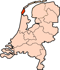
English: Island of Texel, The Netherlands |
||||||||
| Source | Copied from the Wikipedia in french | ||||||||
| Author | fr:Utilisateur:Manchot sanguinaire | ||||||||
| Permission (Reusing this file) |
|

File history
Click on a date/time to view the file as it appeared at that time.
| Date/Time | Thumbnail | Dimensions | User | Comment | |
|---|---|---|---|---|---|
| current | 23:39, 1 January 2005 | | 200 × 235 (22 KB) | Arca~commonswiki (talk | contribs) | Island of Texel, The Netherlands. Copied from the Wikipedia in french. {{GFDL}} |
You cannot overwrite this file.
File usage on Commons
There are no pages that use this file.
File usage on other wikis
The following other wikis use this file:
- Usage on ca.wikipedia.org
- Usage on cs.wikipedia.org
- Usage on es.wikipedia.org
- Usage on fr.wikipedia.org
- Usage on fr.wiktionary.org
- Usage on it.wikipedia.org
- Usage on ko.wikipedia.org
- Usage on sh.wikipedia.org
- Usage on zh.wikipedia.org