File:The Atlantic Neptune, published for the use of the Royal Navy of Great Britain, LOC 75332515-12.jpg

Size of this preview: 800 × 569 pixels. Other resolutions: 320 × 227 pixels | 640 × 455 pixels | 1,024 × 728 pixels | 1,280 × 910 pixels | 2,560 × 1,820 pixels | 12,511 × 8,893 pixels.
Original file (12,511 × 8,893 pixels, file size: 14.34 MB, MIME type: image/jpeg)
Captions
Captions
Add a one-line explanation of what this file represents
Summary
edit| Warning | The original file is very high-resolution. It might not load properly or could cause your browser to freeze when opened at full size. |
|---|
| Description |
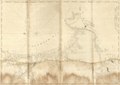
English: L.C. copy no. 20, with 25 items. Consists of the New England section only, in contemporary binding, probably issued in 1780. The general t.p. to v. 1 accompanying it, however, belongs with the Nova Scotia series of charts. In various dated "editions" the New England charts appear with general title pages called v. 2, 3, or 4, but not v. 1. The printed sectional t.p. is undated, and includes the reference to Lord Howe. The printed contents leaf which follows has ms. additions. Of the 23 items listed, no. 9, 12, and 23 are added in ms. No. 16 is omitted. The charts, dated 1775 to 1776, are all 1st or 2d states of the plates, on heavy paper with the "LVG-IV" watermark. L.C. copy imperfect: chart no. 11 of the contents leaf, "The Coast from Newbury to Cape Elizabeth," wanting; 3 other charts are incomplete, especially no. 23, "Grand Bay of Passamaquody," which lacks the "Grand Manan Island" section. In ms. on fly leaf preceding the general t.p.: War Office of the United States. May 7th 1790. Cf. H. N. Stevens. Catalogue of the Henry Newton Stevens collection of the Atlantic Neptune. Available also through the Library of Congress Web site as a raster image. |
||
| Title | The Atlantic Neptune, published for the use of the Royal Navy of Great Britain, | ||
| Shelf ID | G1106.P5 D442 | ||
| Parent | https://www.loc.gov/resource/g3301pm.gan00020/ | ||
| Sheet title | Image 12 of The Atlantic Neptune, published for the use of the Royal Navy of Great Britain, | ||
| Date | |||
| Source | https://www.loc.gov/item/75332515/ | ||
| Author | Des Barres, Joseph F. W. (Joseph Frederick Wallet) | ||
| Permission (Reusing this file) |
|
||
| Other versions |
|
||
| Location | New England. · Atlantic Coast. · North America · New England · United States · Atlantic Coast | ||
| Part of | American Memory · General Maps · Catalog · Geography And Map Division | ||
| Subject | To 1800 · Atlantic Coast (North America) · New England · Nautical Charts · North America · Atlantic Coast · United States |

Licensing
edit
|
This is a faithful photographic reproduction of a two-dimensional, public domain work of art. The work of art itself is in the public domain for the following reason:
The official position taken by the Wikimedia Foundation is that "faithful reproductions of two-dimensional public domain works of art are public domain".
This photographic reproduction is therefore also considered to be in the public domain in the United States. In other jurisdictions, re-use of this content may be restricted; see Reuse of PD-Art photographs for details. | ||||
File history
Click on a date/time to view the file as it appeared at that time.
| Date/Time | Thumbnail | Dimensions | User | Comment | |
|---|---|---|---|---|---|
| current | 17:31, 22 September 2018 | | 12,511 × 8,893 (14.34 MB) | Fæ (talk | contribs) | LOC Maps multisheet https://www.loc.gov/item/75332515/ sheet 12 of 16 #8074 |
You cannot overwrite this file.
File usage on Commons
The following page uses this file: