File:The Crusader States in 1135-gl.svg

Size of this PNG preview of this SVG file: 438 × 599 pixels. Other resolutions: 175 × 240 pixels | 351 × 480 pixels | 561 × 768 pixels | 748 × 1,024 pixels | 1,496 × 2,048 pixels | 966 × 1,322 pixels.
Original file (SVG file, nominally 966 × 1,322 pixels, file size: 220 KB)
Captions
Captions
Add a one-line explanation of what this file represents
Summary edit
| Description |
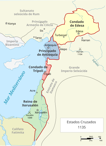
Galego: Mapa dos Estados Cruzados en Próximo Oriente en 1135 |
| Date | |
| Source | https://gl.wikipedia.org/wiki/Ficheiro:Map_Crusader_states_1135-pt.svg |
| Author | MapMaster |
Licensing edit
This file is licensed under the Creative Commons Attribution 3.0 Unported license.
- You are free:
- to share – to copy, distribute and transmit the work
- to remix – to adapt the work
- Under the following conditions:
- attribution – You must give appropriate credit, provide a link to the license, and indicate if changes were made. You may do so in any reasonable manner, but not in any way that suggests the licensor endorses you or your use.
File history
Click on a date/time to view the file as it appeared at that time.
| Date/Time | Thumbnail | Dimensions | User | Comment | |
|---|---|---|---|---|---|
| current | 17:26, 10 May 2024 | | 966 × 1,322 (220 KB) | MAGHOI (talk | contribs) | Uploaded a work by MapMaster from https://gl.wikipedia.org/wiki/Ficheiro:Map_Crusader_states_1135-pt.svg with UploadWizard |
You cannot overwrite this file.
File usage on Commons
The following 29 pages use this file:
- User:Magog the Ogre/Multilingual legend/2024 May 9-12
- File:Crusader States (1135)-ka.png
- File:Lähis-Ida 1135.png
- File:Map Crusader states 1135-ar.png
- File:Map Crusader states 1135-cs.svg
- File:Map Crusader states 1135-de.svg
- File:Map Crusader states 1135-de2.svg
- File:Map Crusader states 1135-el.svg
- File:Map Crusader states 1135-en.svg
- File:Map Crusader states 1135-eo.svg
- File:Map Crusader states 1135-es.svg
- File:Map Crusader states 1135-es2.svg
- File:Map Crusader states 1135-fr.svg
- File:Map Crusader states 1135-fr2.svg
- File:Map Crusader states 1135-hu.svg
- File:Map Crusader states 1135-hy.svg
- File:Map Crusader states 1135-it.png
- File:Map Crusader states 1135-jp.png
- File:Map Crusader states 1135-mk.svg
- File:Map Crusader states 1135-nl.svg
- File:Map Crusader states 1135-pl.png
- File:Map Crusader states 1135-pl.svg
- File:Map Crusader states 1135-pt.svg
- File:Map Crusader states 1135-ru.svg
- File:Map Crusader states 1135-zh.svg
- File:Map Crusads states 1135-fa.png
- File:The Crusader States in 1135-ar.svg
- File:The Crusader States in 1135.svg
- Template:Other versions/Map Crusader states 1135
-ka.png)
File usage on other wikis
The following other wikis use this file:
- Usage on gl.wikipedia.org