File:The Danish Commonwealth.gif

Size of this preview: 557 × 599 pixels. Other resolutions: 223 × 240 pixels | 446 × 480 pixels | 656 × 706 pixels.
Original file (656 × 706 pixels, file size: 45 KB, MIME type: image/gif)
Captions
Captions
Add a one-line explanation of what this file represents

|
This locator map image could be re-created using vector graphics as an SVG file. This has several advantages; see Commons:Media for cleanup for more information. If an SVG form of this image is available, please upload it and afterwards replace this template with
{{vector version available|new image name}}.
It is recommended to name the SVG file “The Danish Commonwealth.svg”—then the template Vector version available (or Vva) does not need the new image name parameter. |
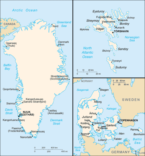
The Danish Commonwealth of Denmark, the Faroe Islands and Greenland.
This image is in the public domain because it contains materials that originally came from the United States Central Intelligence Agency's World Factbook.
|
 |
File history
Click on a date/time to view the file as it appeared at that time.
| Date/Time | Thumbnail | Dimensions | User | Comment | |
|---|---|---|---|---|---|
| current | 00:26, 25 March 2006 | | 656 × 706 (45 KB) | Kasper Holl (talk | contribs) | The Danish Commonwealth of Denmark, the Faroe Islands and Greenland. {{PD-USGov-CIA-WF}} |
You cannot overwrite this file.
File usage on Commons
The following 4 pages use this file:
File usage on other wikis
The following other wikis use this file:
- Usage on ar.wikipedia.org
- Usage on ast.wikipedia.org
- Usage on azb.wikipedia.org
- Usage on az.wikipedia.org
- Usage on be.wikipedia.org
- Usage on bn.wikipedia.org
- Usage on ca.wikipedia.org
- Usage on da.wikipedia.org
- Usage on de.wikipedia.org
- Usage on en.wikipedia.org
- Usage on es.wikipedia.org
- Usage on et.wikipedia.org
- Usage on fa.wikipedia.org
- Usage on fi.wikipedia.org
- Usage on fo.wikipedia.org
- Usage on fr.wikipedia.org
- Usage on gv.wikipedia.org
- Usage on hr.wikipedia.org
- Usage on id.wikipedia.org
- Usage on incubator.wikimedia.org
- Usage on it.wikipedia.org
- Usage on ja.wikipedia.org
- Usage on ko.wikipedia.org
- Usage on nl.wikipedia.org
- Usage on no.wikipedia.org
- Usage on pl.wikipedia.org
- Usage on pt.wikipedia.org
- Geografia da Dinamarca
- Subdivisões da Dinamarca
- Categate
- Lista de ilhas da Dinamarca
- Fronteira Alemanha–Dinamarca
- Pontos extremos da Dinamarca
- Lista de geleiras na Groenlândia
- Estreitos dinamarqueses
- Fronteira Canadá-Dinamarca
- Predefinição:Geografia da Dinamarca
- Relevo da Dinamarca
- Hidrografia da Dinamarca
View more global usage of this file.