File:The First Armenian Republic 1918-1920.gif

No higher resolution available.
The_First_Armenian_Republic_1918-1920.gif (700 × 473 pixels, file size: 64 KB, MIME type: image/gif)
Captions
Captions
Add a one-line explanation of what this file represents
Summary edit
| Description |
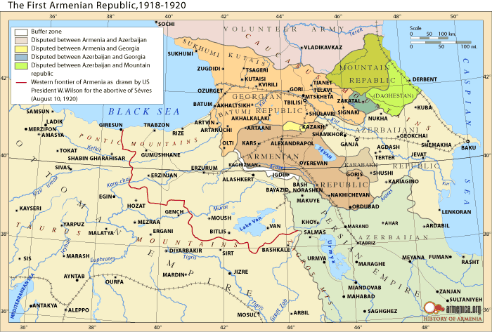
English: An alleged map of the The Democratic Republic of Armenia and the vicinity, 1918-1920. Remains controversial. (The original source of the Map is Robert H. Hewsen's "Armenia: A Historical Atlas" (2001), page 236. |
| Date | Uploaded to Armenica.org before 7 December 2006 (archived version) |
| Source | www.armenica.org |
| Author | www.armenica.org |

|
Attribution information, such as the author's name, e-mail, website, or signature, that was once visible in the image itself has been moved into the image metadata and/or image description page. This makes the image easier to reuse and more language-neutral, and makes the text easier to process and search for. Commons discourages placing visible author information in images.
|
Licensing edit

|
Permission is granted to copy, distribute and/or modify this document under the terms of the GNU Free Documentation License, Version 1.2 or any later version published by the Free Software Foundation; with no Invariant Sections, no Front-Cover Texts, and no Back-Cover Texts. A copy of the license is included in the section entitled GNU Free Documentation License. |
This permission only applies to images existing on http://armenica.org/ as of 1 January 2007. Any later images do not fall under this permission!
File history
Click on a date/time to view the file as it appeared at that time.
| Date/Time | Thumbnail | Dimensions | User | Comment | |
|---|---|---|---|---|---|
| current | 00:34, 16 February 2012 | | 700 × 473 (64 KB) | Centpacrr (talk | contribs) | wmr |
| 22:41, 10 December 2008 |  | 700 × 473 (65 KB) | Serouj (talk | contribs) | {{Information |Description={{en|1=A map of the The Democratic Republic of Armenia and the vicinity, 1918-1920. (The original source of the Map is Robert H. Hewsen's "Armenia: A Historical Atl |
You cannot overwrite this file.
File usage on Commons
The following page uses this file:
File usage on other wikis
The following other wikis use this file:
- Usage on ar.wikipedia.org
- Usage on azb.wikipedia.org
- Usage on be-tarask.wikipedia.org
- Usage on be.wikipedia.org
- Usage on bg.wikipedia.org
- Usage on cs.wikipedia.org
- Usage on de.wikipedia.org
- Usage on en.wikipedia.org
- Usage on et.wikipedia.org
- Usage on fr.wikipedia.org
- Usage on hr.wikipedia.org
- Usage on hy.wikipedia.org
- Usage on it.wikipedia.org
- Usage on ka.wikipedia.org
- Usage on la.wikipedia.org
- Usage on lt.wikipedia.org
- Usage on mk.wikipedia.org
- Usage on pnb.wikipedia.org
- Usage on pt.wikipedia.org
- Usage on ru.wikipedia.org
- Usage on sr.wikipedia.org
- Usage on su.wikipedia.org
- Usage on tr.wikipedia.org
- Usage on uk.wikipedia.org
- Usage on ur.wikipedia.org
- Usage on xmf.wikipedia.org