File:The Peacock, Tudor Lodge, Tudor Cottage and The Smithy, The Square, Chilham, Kent-geograph-5072010-by-Jo-Turner.jpg

Size of this preview: 800 × 353 pixels. Other resolutions: 320 × 141 pixels | 640 × 283 pixels | 1,024 × 452 pixels | 1,280 × 565 pixels | 2,560 × 1,131 pixels | 8,307 × 3,669 pixels.
Original file (8,307 × 3,669 pixels, file size: 4.15 MB, MIME type: image/jpeg)
Captions
Captions
Add a one-line explanation of what this file represents
Summary edit
| Description |
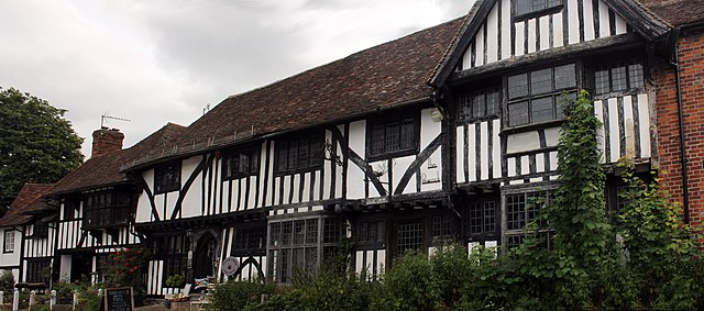
English: The Peacock, Tudor Lodge, Tudor Cottage and The Smithy, The Square, Chilham. All Grade II Listed, The Peacock and Tudor Lodge is a 16th century hall house with 17th and 20th century alterations. The 4 left hand bays are on a Wealden Hall plan. Tudor Lodge Gift Shop on its website describes the building as 14th century and www.Chilham-Parish.org.uk dates it and Peacock Antiques to 1370-1410. The ground floor and fenestration is largely 20th century. Shown in a Francis Frith picture of 1903 The Peacock and Tudor Lodge are described as The Post Office. Tudor cottage in the same photo is brick faced, one and a half story, centre doorway with two second story half dormers windows. By a photo in 1955 the current façade is in place along the whole block. Previous listed Kennetts House, Tudor Cottage and The Smithy are described by the owners as a 'stone building', a blacksmiths then a private home, converted to 'Tudor style' late in the 19th century and divided in two in the 1960s. The couple who now live in Australia bought the cottages in 2003 and currently rent out The Smithy as a holiday home. The listing describes The Smithy and Tudor Cottage as a 17th century cottage pair with 20th century alterations and restored timber framing. Partly in view at the end is Chantry Cottage. |
| Date | |
| Source | https://www.geograph.org.uk/photo/5072010 |
| Author | Jo Turner |
| Attribution (required by the license) | Jo Turner / The Peacock, Tudor Lodge, Tudor Cottage and The Smithy, The Square, Chilham / |
| Camera location | | View this and other nearby images on: OpenStreetMap |
|---|
_heading:67.00&language=en)
| Object location | | View this and other nearby images on: OpenStreetMap |
|---|
_heading:67.00&language=en)
Licensing edit

|
This image was taken from the Geograph project collection. See this photograph's page on the Geograph website for the photographer's contact details. The copyright on this image is owned by Jo Turner and is licensed for reuse under the Creative Commons Attribution-ShareAlike 2.0 license.
|
This file is licensed under the Creative Commons Attribution-Share Alike 2.0 Generic license.
Attribution: Jo Turner
- You are free:
- to share – to copy, distribute and transmit the work
- to remix – to adapt the work
- Under the following conditions:
- attribution – You must give appropriate credit, provide a link to the license, and indicate if changes were made. You may do so in any reasonable manner, but not in any way that suggests the licensor endorses you or your use.
- share alike – If you remix, transform, or build upon the material, you must distribute your contributions under the same or compatible license as the original.
File history
Click on a date/time to view the file as it appeared at that time.
| Date/Time | Thumbnail | Dimensions | User | Comment | |
|---|---|---|---|---|---|
| current | 03:25, 27 December 2016 | | 8,307 × 3,669 (4.15 MB) | Judithcomm (talk | contribs) | User created page with UploadWizard |
You cannot overwrite this file.
File usage on Commons
There are no pages that use this file.