File:The Years of Rice and Salt (Pre-War Map).png

Size of this preview: 800 × 407 pixels. Other resolutions: 320 × 163 pixels | 640 × 325 pixels | 1,024 × 521 pixels | 1,280 × 651 pixels | 2,753 × 1,400 pixels.
Original file (2,753 × 1,400 pixels, file size: 118 KB, MIME type: image/png)
Captions
Captions
Add a one-line explanation of what this file represents
Summary edit
.png&action=edit§ion=1)
| Description |
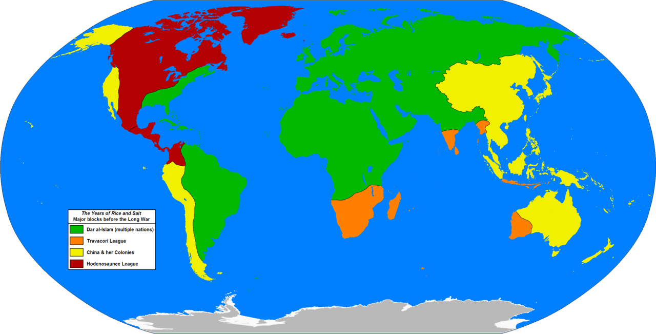
English: A map of the world of the alternate history book "The Years of Rice and Salt", by Kim Stanley Robinson. This map is based on one from the book (which is credited to Jeffrey L. Ward), it shows the four main blocs or alliances on the eve of the "Long War" (specific date is 1333 AH or 1915 AD).
This is not an exact copy of the map in the book, which is very different; being a hand drawn map which uses an unusual map projection. The borders are correct to the book, however some areas are not shown properly on the book's map and so I have had to interpolate a bit (i.e. the book's map does not show the Caribbean islands at all, so I have just chosen to assign them to Dar al-Islam as this seems the most logical based on the history contained in the novel). |
| Date | |
| Source | Own work |
| Author | Hibernian |
Licensing edit
.png&action=edit§ion=2)
I, the copyright holder of this work, hereby publish it under the following license:
| This file is made available under the Creative Commons CC0 1.0 Universal Public Domain Dedication. | |
| The person who associated a work with this deed has dedicated the work to the public domain by waiving all of their rights to the work worldwide under copyright law, including all related and neighboring rights, to the extent allowed by law. You can copy, modify, distribute and perform the work, even for commercial purposes, all without asking permission.
|
File history
Click on a date/time to view the file as it appeared at that time.
| Date/Time | Thumbnail | Dimensions | User | Comment | |
|---|---|---|---|---|---|
| current | 22:02, 17 November 2014 | | 2,753 × 1,400 (118 KB) | Hibernian (talk | contribs) | Minor corrections, the borders on Hispaniola and Timor were in the colour of the sea, when they should have been filled in with the colour of the political entity. |
| 00:07, 10 December 2013 |  | 2,753 × 1,400 (118 KB) | Hibernian (talk | contribs) | minor fix | |
| 21:40, 9 December 2013 |  | 2,753 × 1,400 (118 KB) | Hibernian (talk | contribs) | User created page with UploadWizard |
You cannot overwrite this file.
File usage on Commons
There are no pages that use this file.
File usage on other wikis
The following other wikis use this file:
- Usage on en.wikipedia.org
- Usage on hu.wikipedia.org
- Usage on uk.wikipedia.org
.png&oldid=534613068)