File:The flooded ford at Eynsford (geograph 5736359).jpg

Size of this preview: 800 × 600 pixels. Other resolutions: 320 × 240 pixels | 640 × 480 pixels | 1,024 × 768 pixels | 1,280 × 960 pixels | 2,560 × 1,920 pixels | 4,000 × 3,000 pixels.
Original file (4,000 × 3,000 pixels, file size: 4.88 MB, MIME type: image/jpeg)
Captions
Captions
Add a one-line explanation of what this file represents
Summary edit
.jpg&action=edit§ion=1)
| Description |
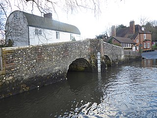
English: The flooded ford at Eynsford. The River Darent rises on the northern side of the Greensand Ridge, to the south of Westerham, and reaches the Thames at Dartford Creek. The ford across the Darent at Eynsford is possibly the most photographed scene in Kent. On this day, after a particularly wet winter, the river was flowing with considerable force. At the ford the water was two feet deep and nobody was foolhardy enough to try driving through it. |
| Date | |
| Source | From geograph.org.uk |
| Author | Marathon |
| Permission (Reusing this file) |
Creative Commons Attribution Share-alike license 2.0 |
| Attribution (required by the license) | Marathon / The flooded ford at Eynsford / |
| Camera location | | View this and other nearby images on: OpenStreetMap |
|---|
.jpg¶ms=051.367784_N_0000.210455_E_globe:Earth_type:camera_source:geograph-osgb36(TQ53976551)_heading:45.00&language=en)
| Object location | | View this and other nearby images on: OpenStreetMap |
|---|
.jpg¶ms=051.367870_N_0000.210600_E_globe:Earth_class:object_type:object_source:geograph-osgb36(TQ53986552)_heading:45.00&language=en)
Licensing edit
.jpg&action=edit§ion=2)

|
This image was taken from the Geograph project collection. See this photograph's page on the Geograph website for the photographer's contact details. The copyright on this image is owned by Marathon and is licensed for reuse under the Creative Commons Attribution-ShareAlike 2.0 license.
|
This file is licensed under the Creative Commons Attribution-Share Alike 2.0 Generic license.
Attribution: Marathon
- You are free:
- to share – to copy, distribute and transmit the work
- to remix – to adapt the work
- Under the following conditions:
- attribution – You must give appropriate credit, provide a link to the license, and indicate if changes were made. You may do so in any reasonable manner, but not in any way that suggests the licensor endorses you or your use.
- share alike – If you remix, transform, or build upon the material, you must distribute your contributions under the same or compatible license as the original.
File history
Click on a date/time to view the file as it appeared at that time.
| Date/Time | Thumbnail | Dimensions | User | Comment | |
|---|---|---|---|---|---|
| current | 18:33, 13 April 2018 | | 4,000 × 3,000 (4.88 MB) | Chris j wood (talk | contribs) | Transferred from geograph.co.uk using [https://tools.wmflabs.org/geograph2commons/ geograph2commons] |
You cannot overwrite this file.
File usage on Commons
There are no pages that use this file.
.jpg&oldid=545966917)