File:The joint problem, 1940.jpg

Size of this preview: 480 × 600 pixels. Other resolutions: 192 × 240 pixels | 384 × 480 pixels | 614 × 768 pixels | 819 × 1,024 pixels | 1,652 × 2,065 pixels.
Original file (1,652 × 2,065 pixels, file size: 611 KB, MIME type: image/jpeg)
Captions
Captions
Add a one-line explanation of what this file represents
Summary
edit
| Description |
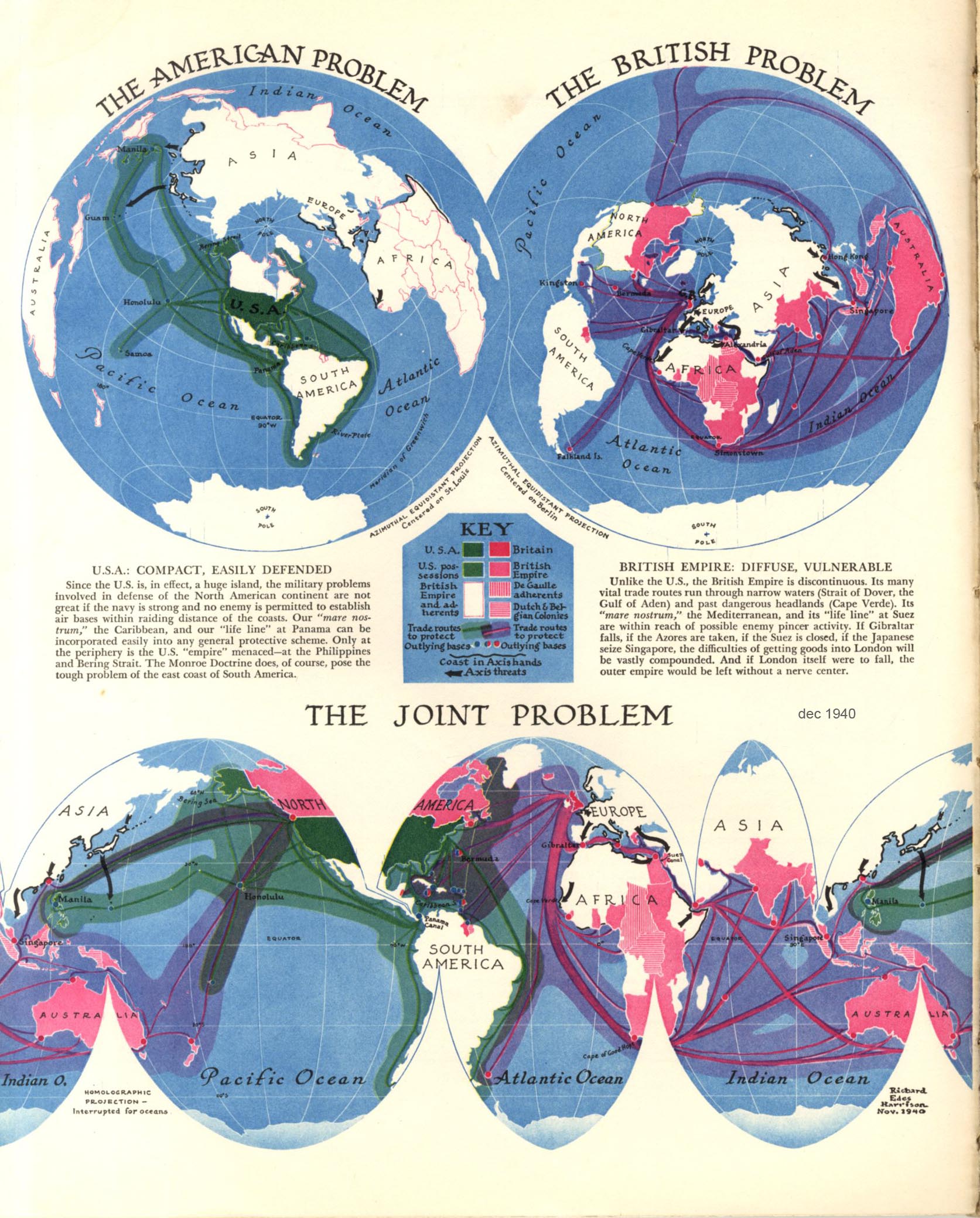
English: Map that showcases the geographical challenges the US and the UK had to face in 1940, using both the azimuthal equidistant projection and an interrupted Mollweide projection. Published in the American magazine Fortune. |
| Date | |
| Source | https://www.fulltable.com/vts/f/fortune/MAPS/gg/SH304.jpg |
| Author | Richard Edes Harrison |
Licensing
edit
This work is in the public domain because it was published in the United States between 1929 and 1963, and although there may or may not have been a copyright notice, the copyright was not renewed. For further explanation, see Commons:Hirtle chart and the copyright renewal logs. Note that it may still be copyrighted in jurisdictions that do not apply the rule of the shorter term for US works (depending on the date of the author's death), such as Canada (70 years p.m.a.), Mainland China (50 years p.m.a., not Hong Kong or Macao), Germany (70 years p.m.a.), Mexico (100 years p.m.a.), Switzerland (70 years p.m.a.), and other countries with individual treaties.
|
 |
File history
Click on a date/time to view the file as it appeared at that time.
| Date/Time | Thumbnail | Dimensions | User | Comment | |
|---|---|---|---|---|---|
| current | 18:23, 12 October 2023 | | 1,652 × 2,065 (611 KB) | User-duck (talk | contribs) | Cropped rough edge using CropTool with lossless mode. |
| 19:49, 28 August 2022 |  | 1,673 × 2,080 (478 KB) | Universalis (talk | contribs) | Uploaded a work by Richard Edes Harrison from https://www.fulltable.com/vts/f/fortune/MAPS/gg/SH304.jpg with UploadWizard |
You cannot overwrite this file.
File usage on Commons
The following 2 pages use this file: