File:Theoretical Search Area MH370.en.svg

Size of this PNG preview of this SVG file: 800 × 515 pixels. Other resolutions: 320 × 206 pixels | 640 × 412 pixels | 1,024 × 659 pixels | 1,280 × 824 pixels | 2,560 × 1,649 pixels | 1,090 × 702 pixels.
Original file (SVG file, nominally 1,090 × 702 pixels, file size: 1.62 MB)
Captions
Captions
Add a one-line explanation of what this file represents
Summary edit
| Description |
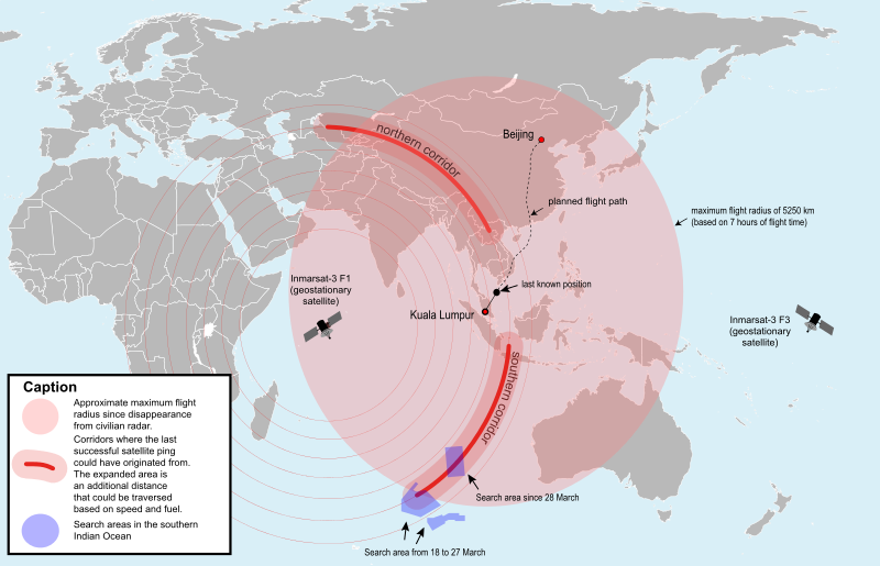
English: Map of the area where Malaysia Airlines Flight 370 could be found theoretically (svg version) (English) |
| Date | |
| Source |
This file was derived from: Theoretical Search Area MH370.svg |
| Author |
|
| SVG development | This W3C-invalid map was created with Adobe Illustrator. |
Licensing edit
I, the copyright holder of this work, hereby publish it under the following license:
This file is licensed under the Creative Commons Attribution-Share Alike 3.0 Unported license.
- You are free:
- to share – to copy, distribute and transmit the work
- to remix – to adapt the work
- Under the following conditions:
- attribution – You must give appropriate credit, provide a link to the license, and indicate if changes were made. You may do so in any reasonable manner, but not in any way that suggests the licensor endorses you or your use.
- share alike – If you remix, transform, or build upon the material, you must distribute your contributions under the same or compatible license as the original.
File history
Click on a date/time to view the file as it appeared at that time.
| Date/Time | Thumbnail | Dimensions | User | Comment | |
|---|---|---|---|---|---|
| current | 00:28, 30 March 2014 | | 1,090 × 702 (1.62 MB) | Furfur (talk | contribs) | cosmetics |
| 00:25, 30 March 2014 |  | 1,090 × 702 (1.38 MB) | Furfur (talk | contribs) | added details | |
| 21:22, 29 March 2014 |  | 1,102 × 688 (1.37 MB) | CommonMarks (talk | contribs) | User created page with UploadWizard |
You cannot overwrite this file.
File usage on Commons
The following page uses this file:
File usage on other wikis
The following other wikis use this file:
- Usage on en.wikipedia.org