File:Thornton Bldg, 6th Avenue, Seattle.png

Size of this preview: 800 × 597 pixels. Other resolutions: 320 × 239 pixels | 640 × 478 pixels | 1,024 × 765 pixels | 1,280 × 956 pixels | 1,520 × 1,135 pixels.
Original file (1,520 × 1,135 pixels, file size: 1.84 MB, MIME type: image/png)
Captions
Captions
Add a one-line explanation of what this file represents
Summary edit
| Description |
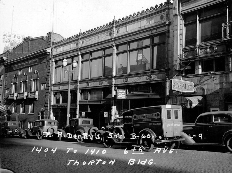
English: The east side of the 1400 block of 6th Avenue between Union and Pike, Seattle in the late 1930s. The Thornton Building (1926, Henry Bittman) is in the foreground and the Salvation Army Hall (1920, Earl A. Roberts) is next door. The sign for the Roosevelt Hotel can be seen in the background. None of these buildings (Except the Roosevelt) still stand. The entire block was replaced by the Sheraton Hotel tower in 1982. |
| Date | |
| Source | King County Assessor, Real Property Record Cards, 1937-1972, Washington State Archives, Digital Archives, http://digitalarchives.wa.gov |
| Author | King County Assessor |
Licensing edit
| This file is made available under the Creative Commons CC0 1.0 Universal Public Domain Dedication. | |
| The person who associated a work with this deed has dedicated the work to the public domain by waiving all of their rights to the work worldwide under copyright law, including all related and neighboring rights, to the extent allowed by law. You can copy, modify, distribute and perform the work, even for commercial purposes, all without asking permission.
|
File history
Click on a date/time to view the file as it appeared at that time.
| Date/Time | Thumbnail | Dimensions | User | Comment | |
|---|---|---|---|---|---|
| current | 04:23, 24 April 2022 | | 1,520 × 1,135 (1.84 MB) | Publichall (talk | contribs) | Uploaded a work by King County Assessor from King County Assessor, Real Property Record Cards, 1937-1972, Washington State Archives, Digital Archives, http://digitalarchives.wa.gov with UploadWizard |
You cannot overwrite this file.
File usage on Commons
There are no pages that use this file.