File:Three Sisters Range geologic map-fr.svg

Size of this PNG preview of this SVG file: 455 × 599 pixels. Other resolutions: 182 × 240 pixels | 364 × 480 pixels | 583 × 768 pixels | 778 × 1,024 pixels | 1,556 × 2,048 pixels | 3,305 × 4,351 pixels.
Original file (SVG file, nominally 3,305 × 4,351 pixels, file size: 2.91 MB)
Captions
Captions
Add a one-line explanation of what this file represents
Summary edit
| Camera location | | View this and other nearby images on: OpenStreetMap |
|---|
| Description |
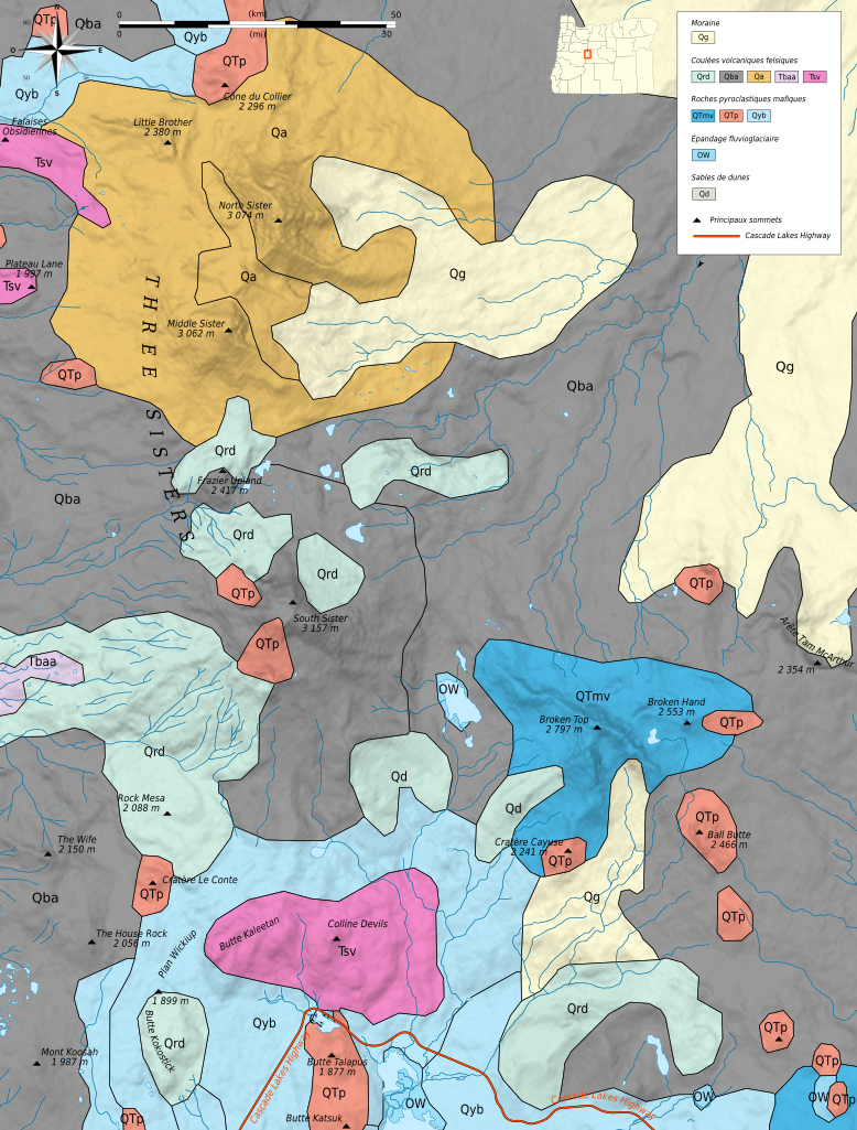
Français : Carte géologique en français de la chaîne des Three Sisters. Deutsch: Geologische Karte die Three Sisters, in Französische. English: Geologic map in French language of Three Sisters.
|
||
| Date | Bourrichon (talk) | ||
| Source |
Création personnelle ;
NASA Shuttle Radar Topography Mission (SRTM3 v.2) (domaine public) ;
US Census Bureau : USDA Forest Service ; légende et couleurs d'après Corvallis Forestry Research Community (detailled geological appendice) ;
|
||
| Author | © Bourrichon (talk) - fr:Bourrichon | ||
| Permission (Reusing this file) |
|
||
| Other versions | File:Three Sisters Range topographic map-fr.svg, File:Three Sisters ASTER 2005-11-10.jpg et File:Three Sisters ASTER 2005-10-25.jpg (même emprise) |

|
This SVG file contains embedded text that can be translated into your language, using any capable SVG editor, text editor or the SVG Translate tool. For more information see: About translating SVG files. |
This W3C-unspecified vector image was created with Inkscape .
Licensing edit
I, the copyright holder of this work, hereby publish it under the following licenses:

|
Permission is granted to copy, distribute and/or modify this document under the terms of the GNU Free Documentation License, Version 1.2 or any later version published by the Free Software Foundation; with no Invariant Sections, no Front-Cover Texts, and no Back-Cover Texts. A copy of the license is included in the section entitled GNU Free Documentation License. |
This file is licensed under the Creative Commons Attribution-Share Alike 3.0 Unported, 2.5 Generic, 2.0 Generic and 1.0 Generic license.
- You are free:
- to share – to copy, distribute and transmit the work
- to remix – to adapt the work
- Under the following conditions:
- attribution – You must give appropriate credit, provide a link to the license, and indicate if changes were made. You may do so in any reasonable manner, but not in any way that suggests the licensor endorses you or your use.
- share alike – If you remix, transform, or build upon the material, you must distribute your contributions under the same or compatible license as the original.
You may select the license of your choice.
File history
Click on a date/time to view the file as it appeared at that time.
| Date/Time | Thumbnail | Dimensions | User | Comment | |
|---|---|---|---|---|---|
| current | 14:18, 30 April 2013 | | 3,305 × 4,351 (2.91 MB) | Bourrichon (talk | contribs) | {{Location|44|06|13|N|121|46|10|W|scale:50000}} {{Information|Description={{fr|Carte géologique en français de la chaîne des Three Sisters.}}{{de|Geologische Karte die Three Sisters, in F... |
You cannot overwrite this file.
File usage on Commons
The following page uses this file:
File usage on other wikis
The following other wikis use this file:
- Usage on fr.wikipedia.org
- Usage on it.wikipedia.org