File:Three Sisters topographic map-fr.svg

Size of this PNG preview of this SVG file: 515 × 599 pixels. Other resolutions: 206 × 240 pixels | 412 × 480 pixels | 660 × 768 pixels | 880 × 1,024 pixels | 1,759 × 2,048 pixels | 2,835 × 3,300 pixels.
Original file (SVG file, nominally 2,835 × 3,300 pixels, file size: 4.72 MB)
Captions
Captions
Add a one-line explanation of what this file represents
Summary edit
| Description |
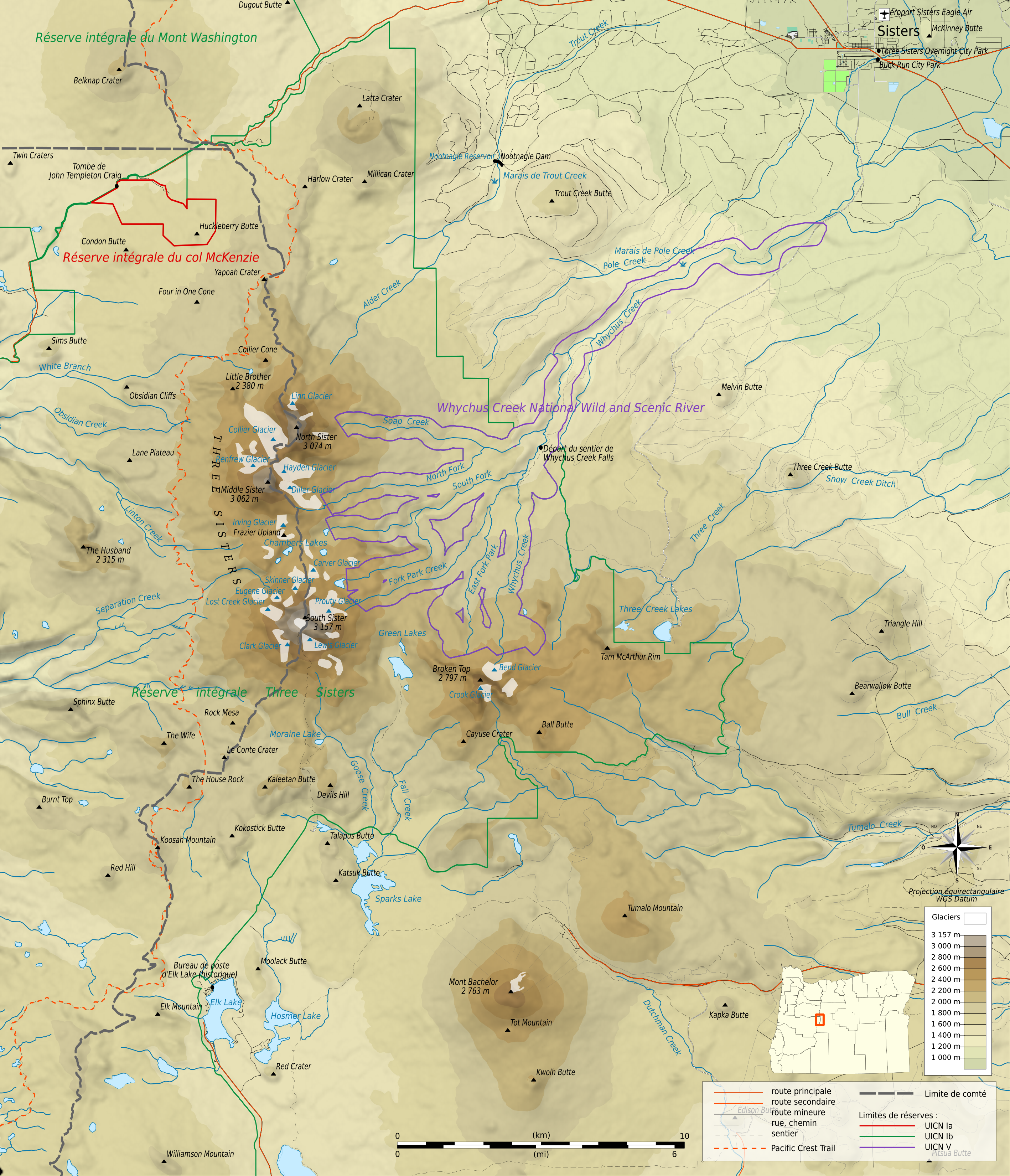
Français : Carte topographique en français de la chaîne des Three Sisters.
Deutsch: Topographische Karte die Three Sisters, in Französische.
English: Topographic map in French language of Three Sisters. |
||
| Date | (UTC) | ||
| Source | Own work | ||
| Author | © Bourrichon (talk) - fr:Bourrichon | ||
| Permission (Reusing this file) |
|
||
| Other versions |
File:Three Sisters ASTER 2006-06-22.jpg (même emprise) File:Three Sisters topographic map-en.svg |
||
| Approximate scale | of topographic data: 1:372,000 (accuracy : about 93 m) | ||
| Approximate geographic limits of the map |
|
||
| Projection | équirectangulaire + vertical stretching 20% | ||
| Geodesic system | WGS84 | ||
| Shaded relief | N-W lightning position.The shaded relief is a raster image embedded in the SVG file. | ||
| Topographic data | NASA Shuttle Radar Topography Mission (SRTM3 v.2) (domaine public) | ||
| Hydrographic and administrative limit data | US Census Bureau : TIGER | ||
| Places, transportation | données de la carte © les contributeurs d'OpenStreetMap, CC-BY-SA Openstreetmap | ||
| Locator map | dérivée de File:Map of Oregon highlighting Klamath County.svg by David Benbennick | ||
| Other sources | Peakbagger | ||
| Other symbols | provenant de File:Maps template-fr.svg. | ||
| Software used | (méthode décrite dans ce didacticiel) :
|
| Camera location | | View this and other nearby images on: OpenStreetMap |
|---|

|
This SVG file contains embedded text that can be translated into your language, using any capable SVG editor, text editor or the SVG Translate tool. For more information see: About translating SVG files. |
This W3C-unspecified vector image was created with Inkscape .
Licensing edit
I, the copyright holder of this work, hereby publish it under the following licenses:

|
Permission is granted to copy, distribute and/or modify this document under the terms of the GNU Free Documentation License, Version 1.2 or any later version published by the Free Software Foundation; with no Invariant Sections, no Front-Cover Texts, and no Back-Cover Texts. A copy of the license is included in the section entitled GNU Free Documentation License. |
This file is licensed under the Creative Commons Attribution-Share Alike 3.0 Unported, 2.5 Generic, 2.0 Generic and 1.0 Generic license.
- You are free:
- to share – to copy, distribute and transmit the work
- to remix – to adapt the work
- Under the following conditions:
- attribution – You must give appropriate credit, provide a link to the license, and indicate if changes were made. You may do so in any reasonable manner, but not in any way that suggests the licensor endorses you or your use.
- share alike – If you remix, transform, or build upon the material, you must distribute your contributions under the same or compatible license as the original.
You may select the license of your choice.
File history
Click on a date/time to view the file as it appeared at that time.
| Date/Time | Thumbnail | Dimensions | User | Comment | |
|---|---|---|---|---|---|
| current | 19:55, 13 April 2013 | | 2,835 × 3,300 (4.72 MB) | Bourrichon (talk | contribs) | |
| 15:55, 13 April 2013 |  | 2,835 × 3,300 (4.72 MB) | Bourrichon (talk | contribs) | ||
| 15:35, 13 April 2013 |  | 2,835 × 3,300 (4.72 MB) | Bourrichon (talk | contribs) | ||
| 14:40, 13 April 2013 |  | 2,835 × 3,300 (4.73 MB) | Bourrichon (talk | contribs) | == {{int:filedesc}} == {{Location|44|06|13|N|121|46|10|E|scale:50000}} {{Information |Description= {{fr|Carte topographique en français de la chaîne des fr:Three Sisters (oregon).}} {{de|Topographische Karte die de:Three Sisters (Oregon)... |
You cannot overwrite this file.
File usage on Commons
There are no pages that use this file.
File usage on other wikis
The following other wikis use this file: