File:Timothy Treadwell 2003-10-06 incident sketch.gif

Original file (920 × 1,053 pixels, file size: 23 KB, MIME type: image/gif)
Captions
Captions
Summary edit
| Description |
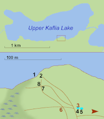
English: Attempt to improve on below quoted sketch by using approximate distances in between relevant waypoints as provided by Ranger Joel Ellis. Brown arrow indicates a major bear trail leading to the "creek of the salmon run". Numbers mean:
1 - Floatplane moored Deutsch: Diese Skizze basiert auf den von Ranger Joel Ellis 2003 angegebenen Distanzen und seiner unten verlinkten Handskizze, sowie dem GPS-Wegpunkt (Annahme: Amies Leiche, 2m vom Schlafzelt). Da die Karte und das einzige mir verfügbare Satellitenbild um rund 30m differieren wurde hier die Karte entsprechend nachgebessert. Die eingetragenen Positionen sind aber jedenfalls ungenau, da 2m bloß ~15 Pixeln entsprächen. Die Skizze soll vor allem die räumliche Enge und Gefährlichkeit des Zeltplatzes verdeutlichen. Der braune Pfeil bezeichnet den vielbenutzten Bärenpfad zu dem Bach in dem die Bären Lachse fischten. |
| Date | |
| Source | OSM, satellite view and data (distances) from File:Treadwell Incident Map.jpg |
| Author | user:W. |
| Permission (Reusing this file) |
w., the copyright holder of this work, hereby publishes it under the following license: This file is licensed under the Creative Commons Attribution-Share Alike 3.0 Unported license. Attribution: Wolfgang H. Wögerer, Vienna, Austria
|
| Other versions |
  |
| Object location | | View this and other nearby images on: OpenStreetMap |
|---|
File history
Click on a date/time to view the file as it appeared at that time.
| Date/Time | Thumbnail | Dimensions | User | Comment | |
|---|---|---|---|---|---|
| current | 10:23, 24 September 2012 | | 920 × 1,053 (23 KB) | W. (talk | contribs) | corr. error on bear trails and positions of WPs 7&8, relative to bear trails. Removed EN descriptions for better international use, replacing "marsh" by chart symbol. |
| 13:14, 23 September 2012 |  | 920 × 1,053 (24 KB) | W. (talk | contribs) | == {{int:filedesc}} == {{Information |Description={{en|Attempt to improve on below quoted sketch by using approximate distances in between relevant waypoints as provided by Ranger Joel Ellis. <br/>Numbers mean:<br/>1 - Floatplane moored<br/>2 - best a... |
You cannot overwrite this file.
File usage on Commons
The following 2 pages use this file:
File usage on other wikis
The following other wikis use this file:
- Usage on de.wikipedia.org
- Usage on it.wikipedia.org
- Usage on pl.wikipedia.org