File:Tiruchirappalli Rock Fort Housing Thayumanavar Swamy and Ucchi Pillaiyar Temples.jpg

Size of this preview: 800 × 351 pixels. Other resolutions: 320 × 140 pixels | 640 × 281 pixels | 1,024 × 449 pixels | 1,280 × 561 pixels | 3,274 × 1,436 pixels.
Original file (3,274 × 1,436 pixels, file size: 727 KB, MIME type: image/jpeg)
Captions
Captions
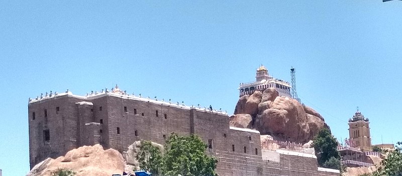
The Rock fort standing atop 273 feet high rock houses Thayumanavar Temple complex and Ucchi Pillayar Temple located at Tiruchirappalli, Tamil Nadu, India
Summary edit
| Description |
English: The Rock Fort is an ancient structure built atop a 272 feet high rock housing a Siva Temple complex and a Ganesh Temple and it is located at Tiruchirappalli, Tamil Nadu, India. The rock on which the temples are built is 3800 million years old. The rock also houses two Pallava era cave temples built by Pallava King Mahendravarman-I(580-630CE). The Rock fort was planned and built by Pallava, Chola, Pandyas, and Madurai Nayaks in different points of time. There are Pallava and Old Tamil incriptions in the pillars and walls of rock-cut cave temples here. Trichy Rock Fort is an ancient heritage monument in India and it stands as a mute witness to various battles and power struggles of Vijaya Nagar Kings, the Nayaks and the British in different points of time. |
|||
| Date | ||||
| Source | Own work | |||
| Author | N. Vivekananthamoorthy | |||
| Other versions |
|


| Camera location | | View this and other nearby images on: OpenStreetMap |
|---|
Licensing edit
I, the copyright holder of this work, hereby publish it under the following license:
This file is licensed under the Creative Commons Attribution-Share Alike 4.0 International license.
- You are free:
- to share – to copy, distribute and transmit the work
- to remix – to adapt the work
- Under the following conditions:
- attribution – You must give appropriate credit, provide a link to the license, and indicate if changes were made. You may do so in any reasonable manner, but not in any way that suggests the licensor endorses you or your use.
- share alike – If you remix, transform, or build upon the material, you must distribute your contributions under the same or compatible license as the original.
File history
Click on a date/time to view the file as it appeared at that time.
| Date/Time | Thumbnail | Dimensions | User | Comment | |
|---|---|---|---|---|---|
| current | 10:01, 29 September 2021 | | 3,274 × 1,436 (727 KB) | LiebeErbeIndien (talk | contribs) | Uploaded own work with UploadWizard |
You cannot overwrite this file.
File usage on Commons
There are no pages that use this file.