File:Tochigi Central Park, CKT20103-C21-38.jpg
Size of this preview: 739 × 600 pixels. Other resolutions: 296 × 240 pixels | 591 × 480 pixels | 861 × 699 pixels.
Original file (861 × 699 pixels, file size: 233 KB, MIME type: image/jpeg)
Captions
Captions
Add a one-line explanation of what this file represents
Summary edit
| Description |
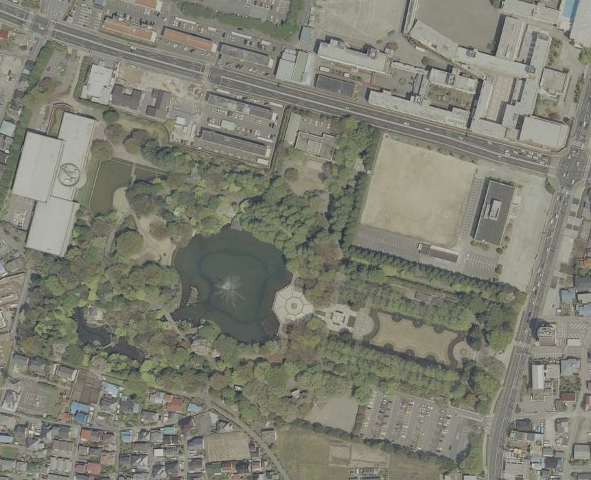
日本語: 栃木県宇都宮市睦町にある、栃木県中央公園の航空写真。
English: This is an aerial photo of Tochigi Central Park in Utsunomiya, Tochigi, Japan. |
| Date | |
| Source |
日本語: 国土画像情報(カラー空中写真)(整理番号:CKT20103、コース番号:C21、写真番号:38、撮影年月日:2010年5月2日、撮影地域:宇都宮、撮影高度:1630m、撮影縮尺:1/10000、カメラ名称:RC30、焦点距離:153.320mm、カラー種別:カラー、写真種別:アナログ、撮影計画機関:国土地理院、市区町村名:宇都宮市) https://mapps.gsi.go.jp/contentsImageDisplay.do?specificationId=487904&isDetail=false
English: National Land Image Information (Color Aerial Photographs) (Reference number: CKT20103; Course Number: C21; Photo Number: 38; Date: May 2, 2010; Area: Utsunomiya; Height: 1630 metre; Scale: 1/10000; Camera Name: RC30; Focal Distance: 153.320 millimetre; Color Type: Color; Photo Type: Analog; Agency: Geographical Survey Institute of Japan; Municipality: Utsunomiya City) https://mapps.gsi.go.jp/contentsImageDisplay.do?specificationId=487904&isDetail=false |
| Author |
English: Geographical Survey Institute of Japan 日本語: 国土地理院 |
| Other versions | File:Utanf & Bunsei, CKT20103-C21-38.jpg |
Licensing edit

|
The copyright holder of this file, Ministry of Land, Infrastructure, Transport and Tourism, allows anyone to use it for any purpose, provided that the copyright holder is properly attributed. Redistribution, derivative work, commercial use, and all other use is permitted. |
Attribution:
National Land Image Information (Color Aerial Photographs), created by Ministry of Land, Infrastructure, Transport and Tourism, distributed by Geospatial Information Authority of Japan
|

File history
Click on a date/time to view the file as it appeared at that time.
| Date/Time | Thumbnail | Dimensions | User | Comment | |
|---|---|---|---|---|---|
| current | 08:39, 3 December 2023 | | 861 × 699 (233 KB) | Miyuki Meinaka (talk | contribs) | Uploaded a work by {{en|1=Geographical Survey Institute of Japan}}{{ja|1=国土地理院}} from https://mapps.gsi.go.jp/contentsImageDisplay.do?specificationId=487904&isDetail=false with UploadWizard |
You cannot overwrite this file.
File usage on Commons
There are no pages that use this file.
File usage on other wikis
The following other wikis use this file:
- Usage on ja.wikipedia.org