File:Togo-karte-politisch-plateaux.png

Size of this preview: 408 × 599 pixels. Other resolutions: 163 × 240 pixels | 425 × 624 pixels.
Original file (425 × 624 pixels, file size: 136 KB, MIME type: image/png)
Captions
Captions
Add a one-line explanation of what this file represents
Summary edit
| Description |
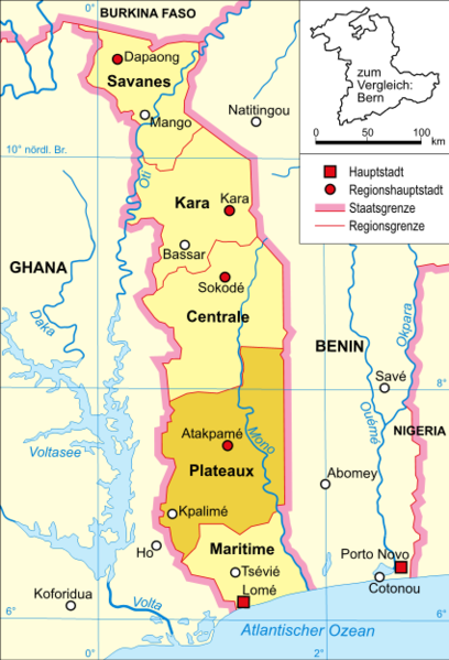
Deutsch: Politische Karte Togos (Region Plateaux hervorgehoben) |
| Date |
13. Januar 2006 |
| Source | Own work (Original text: Selbst erstellt) |
| Author | Domenico-de-ga |
Licensing edit
Domenico-de-ga at the German-language Wikipedia, the copyright holder of this work, hereby publishes it under the following license:

|
Permission is granted to copy, distribute and/or modify this document under the terms of the GNU Free Documentation License, Version 1.2 or any later version published by the Free Software Foundation; with no Invariant Sections, no Front-Cover Texts, and no Back-Cover Texts. A copy of the license is included in the section entitled GNU Free Documentation License. |
| This file is licensed under the Creative Commons Attribution-Share Alike 3.0 Unported license. | ||
| Attribution: Domenico-de-ga | ||
| ||
| This licensing tag was added to this file as part of the GFDL licensing update. |
Original upload log edit
The original description page was here. All following user names refer to de.wikipedia.
- 2006-01-13 15:11 Domenico-de-ga 425×624×8 (139505 bytes) * Bildbeschreibung: politische Karte Togos (Region Plateaux hervorgehoben) * Quelle: selbst erstellt * Zeichner: [[Benutzer:Domenico-de-ga|Domenico-de-ga]] * Datum: 13. Januar 2006 {{Bild-GFDL}}
File history
Click on a date/time to view the file as it appeared at that time.
| Date/Time | Thumbnail | Dimensions | User | Comment | |
|---|---|---|---|---|---|
| current | 22:47, 22 January 2008 | | 425 × 624 (136 KB) | Martin H. (talk | contribs) | {{Information |Description={{de|Politische Karte Togos (Region Plateaux hervorgehoben)}} |Source=Transferred from [http://de.wikipedia.org de.wikipedia]<br/> (Original text : ''Selbst erstellt'') |Date=13. Januar 2006<br/> 2006-01-13 (original upload date |
You cannot overwrite this file.
File usage on Commons
The following 2 pages use this file:
File usage on other wikis
The following other wikis use this file:
- Usage on bg.wikipedia.org
- Usage on ca.wikipedia.org
- Usage on da.wikipedia.org
- Usage on de.wikipedia.org
- Usage on ee.wikipedia.org
- Usage on en.wikipedia.org
- Usage on eo.wikipedia.org
- Usage on fi.wikipedia.org
- Usage on ha.wikipedia.org
- Usage on ig.wikipedia.org
- Usage on ja.wikipedia.org
- Usage on lt.wikipedia.org
- Usage on ro.wikipedia.org
- Usage on ru.wikipedia.org
- Usage on simple.wikipedia.org
- Usage on sv.wikipedia.org
- Usage on sw.wikipedia.org
- Usage on tr.wikipedia.org
- Usage on ts.wikipedia.org
- Usage on www.wikidata.org
- Usage on yo.wikipedia.org
- Usage on zu.wikipedia.org