File:Tokyo Metropolitan Expressway map-ja.svg

Size of this PNG preview of this SVG file: 417 × 599 pixels. Other resolutions: 167 × 240 pixels | 334 × 480 pixels | 534 × 768 pixels | 713 × 1,024 pixels | 1,426 × 2,048 pixels | 6,048 × 8,688 pixels.
Original file (SVG file, nominally 6,048 × 8,688 pixels, file size: 144 KB)
Captions
Captions
Add a one-line explanation of what this file represents
Summary edit
| Description |
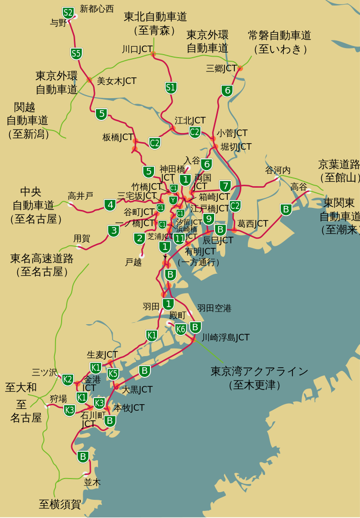
English: Map of the Tokyo Metropolitan Expressway network (red) and connecting expressways (green).
日本語: 首都高速道路(赤)と接続する高速道路・有料道路(緑)の地図。 |
| Date | |
| Source |
日本語: File:Tokyo Metropolitan Expressway map.svgを翻訳、修正。
English: Translated and modified File:Tokyo Metropolitan Expressway map.svg |
| Author | Widehawk (talk), SPUI (File:Tokyo Metropolitan Expressway map.svg) |
| Other versions |
|

Licensing edit
This file is licensed under the Creative Commons Attribution 3.0 Unported license.
- You are free:
- to share – to copy, distribute and transmit the work
- to remix – to adapt the work
- Under the following conditions:
- attribution – You must give appropriate credit, provide a link to the license, and indicate if changes were made. You may do so in any reasonable manner, but not in any way that suggests the licensor endorses you or your use.
File history
Click on a date/time to view the file as it appeared at that time.
| Date/Time | Thumbnail | Dimensions | User | Comment | |
|---|---|---|---|---|---|
| current | 23:58, 30 April 2010 | | 6,048 × 8,688 (144 KB) | DieBuche (talk | contribs) | -raster image. general fixes |
| 16:59, 27 May 2009 |  | 6,048 × 8,688 (396 KB) | Widehawk (talk | contribs) | 字がはみ出してたのを修正 | |
| 16:40, 27 May 2009 |  | 6,048 × 8,688 (395 KB) | Widehawk (talk | contribs) | {{Information |Description={{en|1=Map of the Tokyo Metropolitan Expressway network (red) and connecting expressways (green).}} {{ja|1=首都高速道路(赤)と接続する高速道路・有料道路(緑)の地図。}} |Source={{ja|[[:File:Tokyo M |
You cannot overwrite this file.
File usage on Commons
The following page uses this file: