File:Tomakomai-KokyoRinkosen.jpg

Size of this preview: 600 × 600 pixels. Other resolutions: 240 × 240 pixels | 480 × 480 pixels | 768 × 768 pixels | 1,024 × 1,024 pixels | 2,048 × 2,048 pixels | 3,456 × 3,456 pixels.
Original file (3,456 × 3,456 pixels, file size: 12.99 MB, MIME type: image/jpeg)
Captions
Captions
Add a one-line explanation of what this file represents
Summary edit
| Description |
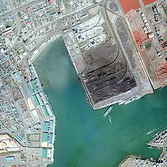
日本語: 苫小牧公共臨港線 1975年。周囲約2km範囲。右上写真外に苫小牧操車場、左上に室蘭本線/日高本線が走り、左が苫小牧駅本構方面。
中央に苫小牧港商港区があり、東側は下からフェリーターミナル、貯炭場と石炭埠頭、セメント配分基地と東埠頭。西側は上から西埠頭、南埠頭で合わせて雑貨埠頭と総称。 |
| Date | |
| Source | 国土交通省 国土画像情報(カラー空中写真)を基に作成、国土交通省国土地理院 地図・空中写真閲覧サービス(2014年9月18日) |
| Author | Nisanyongo |
| Permission (Reusing this file) |
下記を参照して下さい (国土地理院は国土交通省から継承) |
Licensing edit

|
The copyright holder of this file, the Ministry of Land, Infrastructure, Transport and Tourism of Japan, allows anyone to use it for any purpose, provided that the copyright holder is properly attributed. Redistribution, derivative work, commercial use, and all other use is permitted. |
Attribution:
Copyright © National Land Image Information (Color Aerial Photographs), Ministry of Land, Infrastructure, Transport and Tourism
|
 |
This image is copyrighted by the Ministry of Land, Infrastructure, Transport and Tourism of Japan. For terms of use, see the stipulation to use of National Land Information (in Japanese) and message from MLIT (in Japanese and English). When you display this image on an article, include the following phrase in the description: "Made based on National Land Image Information (Color Aerial Photographs), Ministry of Land, Infrastructure, Transport and Tourism".
|
File history
Click on a date/time to view the file as it appeared at that time.
| Date/Time | Thumbnail | Dimensions | User | Comment | |
|---|---|---|---|---|---|
| current | 23:02, 18 September 2014 | | 3,456 × 3,456 (12.99 MB) | Nisanyongo (talk | contribs) | 元画像変更により再アップ |
| 12:08, 4 June 2011 |  | 3,456 × 3,456 (7.97 MB) | Nisanyongo (talk | contribs) | {{Information |Description=苫小牧公共臨港線 1975年。周囲約2km範囲。 |Source={{国土航空写真}} |Date=2011/6/4 |Author=Nisanyongo |Permission=下記を参照して下さい |other_versions= }} {{国土情報航空写真}} |
You cannot overwrite this file.
File usage on Commons
There are no pages that use this file.
File usage on other wikis
The following other wikis use this file:
- Usage on ja.wikipedia.org