File:Topographic map of Buru-ru.svg

Size of this PNG preview of this SVG file: 800 × 598 pixels. Other resolutions: 320 × 239 pixels | 640 × 479 pixels | 1,024 × 766 pixels | 1,280 × 957 pixels | 2,560 × 1,915 pixels | 1,972 × 1,475 pixels.
Original file (SVG file, nominally 1,972 × 1,475 pixels, file size: 1.13 MB)
Captions
Captions
Add a one-line explanation of what this file represents
| Description |
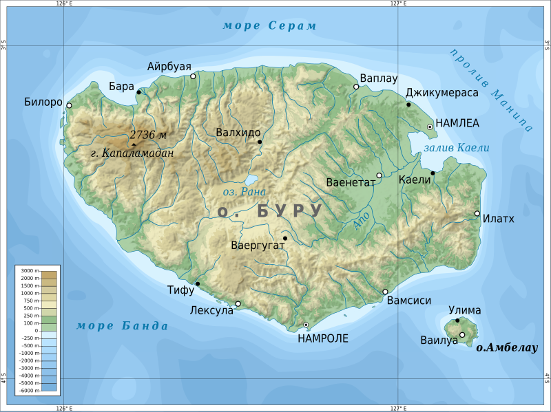
English: Topographic map of Buru island. Русский: Топографическая карта острова Буру. |
| Date | (UTC) |
| Source | |
| Author |
|
| This is a retouched picture, which means that it has been digitally altered from its original version. The original can be viewed here: Topographic map of Buru-en.svg:
|
I, the copyright holder of this work, hereby publish it under the following licenses:
This file is licensed under the Creative Commons Attribution-Share Alike 3.0 Unported license.
- You are free:
- to share – to copy, distribute and transmit the work
- to remix – to adapt the work
- Under the following conditions:
- attribution – You must give appropriate credit, provide a link to the license, and indicate if changes were made. You may do so in any reasonable manner, but not in any way that suggests the licensor endorses you or your use.
- share alike – If you remix, transform, or build upon the material, you must distribute your contributions under the same or compatible license as the original.

|
Permission is granted to copy, distribute and/or modify this document under the terms of the GNU Free Documentation License, Version 1.2 or any later version published by the Free Software Foundation; with no Invariant Sections, no Front-Cover Texts, and no Back-Cover Texts. A copy of the license is included in the section entitled GNU Free Documentation License. |
You may select the license of your choice.
Original upload log edit
This image is a derivative work of the following images:
- File:Topographic_map_of_Buru-en.svg licensed with Cc-by-sa-3.0, GFDL
- 2011-04-16T08:51:51Z Mysid 1972x1475 (1193975 Bytes) remove unnamed town dots
- 2011-04-12T14:34:18Z Mysid 1972x1475 (1195271 Bytes) bugfix #2
- 2011-04-12T14:33:09Z Mysid 1972x1475 (1195269 Bytes) bugfix #1
- 2011-04-12T14:31:11Z Mysid 1972x1475 (1195457 Bytes) {{Information |Description ={{en|1=Topographic map of [[w:en:Buru|Buru]].}} |Source ={{own}}. Self-made in Inkscape and GIMP. |Author =[[w:User:Mysid|Mysid]] |Date =2010-04-12 |Permission = |o
Uploaded with derivativeFX
File history
Click on a date/time to view the file as it appeared at that time.
| Date/Time | Thumbnail | Dimensions | User | Comment | |
|---|---|---|---|---|---|
| current | 07:04, 20 April 2011 | | 1,972 × 1,475 (1.13 MB) | Das steinerne Herz (talk | contribs) | Амбелау |
| 21:16, 19 April 2011 |  | 1,972 × 1,475 (1.12 MB) | Das steinerne Herz (talk | contribs) | fonts | |
| 21:10, 19 April 2011 |  | 1,972 × 1,475 (1.12 MB) | Das steinerne Herz (talk | contribs) | {{Information |Description={{ru|1=Топографическая карта острова Буру.}} |Source=*File:Topographic_map_of_Buru-en.svg |Date=2011-04-19 21:09 (UTC) |Author=*[[:Fi |
You cannot overwrite this file.
File usage on Commons
There are no pages that use this file.
File usage on other wikis
The following other wikis use this file: