File:Topographie Frankreich.jpg
No higher resolution available.
Topographie_Frankreich.jpg (540 × 540 pixels, file size: 102 KB, MIME type: image/jpeg)
Captions
Captions
Add a one-line explanation of what this file represents
Summary edit
| Description |
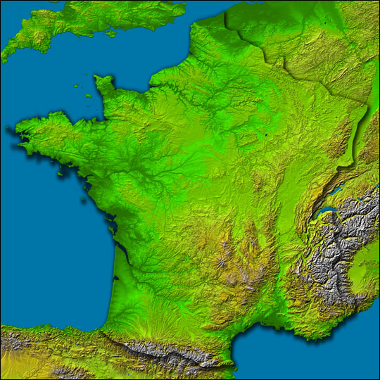
Deutsch: The Topography of France
Location: 42 to 51.5 ° North, 5.5 West to 8 ° East Orientation: North toward the top, Mercator projection Image Data: shaded and colored SRTM elevation model Original Data Resolution: 1 arcsecond (~30 meters) Date Acquired: February 2000 Image Courtesy SRTM Team NASA/JPL/NIMA http://earthobservatory.nasa.gov/Newsroom/NewImages/images.php3?img_id=15360 "Any and all materials published on the Earth Observatory are freely available for re-publication or re-use, except where copyright is indicated." |
| Source | NASA |
| Author | NASA |
Licensing edit
| This file is in the public domain in the United States because it was solely created by NASA. NASA copyright policy states that "NASA material is not protected by copyright unless noted". (See Template:PD-USGov, NASA copyright policy page or JPL Image Use Policy.) | ||
 |
Warnings:
|
Original upload log edit
Transferred from de.wikipedia to Commons by Nachcommonsverschieber using CommonsHelper.
The original description page was here. All following user names refer to de.wikipedia.
- 2004-02-07 17:39 John 540×540× (104801 bytes) The Topography of France, Image Courtesy SRTM Team NASA/JPL/NIMA
File history
Click on a date/time to view the file as it appeared at that time.
| Date/Time | Thumbnail | Dimensions | User | Comment | |
|---|---|---|---|---|---|
| current | 08:54, 1 August 2013 | | 540 × 540 (102 KB) | File Upload Bot (Magnus Manske) (talk | contribs) | Transfered from de.wikipedia by User:Nachcommonsverschieber using CommonsHelper |
You cannot overwrite this file.
File usage on Commons
The following page uses this file:
File usage on other wikis
The following other wikis use this file:
- Usage on de.wikipedia.org