File:Tornado.Indiana.L5.2005-11-10.jpg
No higher resolution available.
Tornado.Indiana.L5.2005-11-10.jpg (540 × 540 pixels, file size: 156 KB, MIME type: image/jpeg)
Captions
Captions
Add a one-line explanation of what this file represents
Summary edit
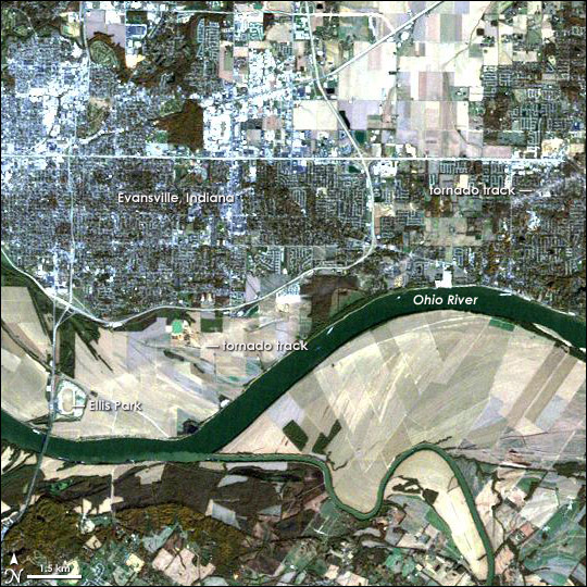
| Description | Landsat image of w:Evansville, Indiana and northern Kentucky after a tornado. Note the pale, interrupted stripe across the image—like someone dragged an eraser across the scene—showing the track the tornado made as it moved from southwest to northeast. |
| Date | |
| Source | http://earthobservatory.nasa.gov/Newsroom/NewImages/images.php3?img_id=17100 |
| Author | NASA Landsat Project Science Office and USGS EROS |
| Permission (Reusing this file) |
US government, public domain |
| Other versions | Larger, uncropped, unannotated version available at source URL. |
Licensing edit
| This file is in the public domain in the United States because it was solely created by NASA. NASA copyright policy states that "NASA material is not protected by copyright unless noted". (See Template:PD-USGov, NASA copyright policy page or JPL Image Use Policy.) | ||
 |
Warnings:
|
File history
Click on a date/time to view the file as it appeared at that time.
| Date/Time | Thumbnail | Dimensions | User | Comment | |
|---|---|---|---|---|---|
| current | 16:31, 2 May 2006 | | 540 × 540 (156 KB) | Holly Cheng (talk | contribs) | {{Information | Description=Landsat image of w:Evansville, Indiana and northern Kentucky after a tornado. Note the pale, interrupted stripe across the image—like someone dragged an eraser across the scene—showing the track the tornado made as it m |
You cannot overwrite this file.
File usage on Commons
There are no pages that use this file.