File:TrabucoCreekCulvert.jpg
No higher resolution available.
TrabucoCreekCulvert.jpg (491 × 515 pixels, file size: 199 KB, MIME type: image/jpeg)
Captions
Captions
Add a one-line explanation of what this file represents
Summary edit
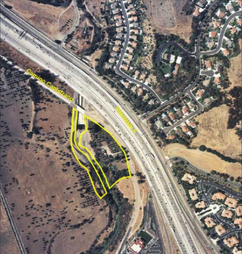
| Description |
English: Where Trabuco Creek meets Interstate 5, with yellow marks indicating areas needing restoration |
| Date | |
| Source | San Juan Creek Watershed Management Feasibility Study |
| Author | U.S. Army Corps of Engineers |
Licensing edit
This image or file is a work of a U.S. Army Corps of Engineers soldier or employee, taken or made as part of that person's official duties. As a work of the U.S. federal government, the image is in the public domain.
|
Original upload log edit
Transferred from en.wikipedia to Commons using For the Common Good.
The original description page was here. All following user names refer to en.wikipedia.
| Date/Time | Dimensions | User | Comment |
|---|---|---|---|
| 17:40, 17 June 2009 | 491 × 515 (203,269 bytes) | w:en:Shannon1 (usurped3) (talk | contribs) | {{Information |Description = Where [[Trabuco Creek]] meets [[Interstate 5]], with yellow marks indicating areas needing restoration |Source = San Juan Creek Watershed Management Feasibility Study |Date = August 2002 |Author |
File history
Click on a date/time to view the file as it appeared at that time.
| Date/Time | Thumbnail | Dimensions | User | Comment | |
|---|---|---|---|---|---|
| current | 07:28, 8 July 2014 | | 491 × 515 (199 KB) | Josve05a (talk | contribs) | Transferred from en.wikipedia: see original upload log above |
You cannot overwrite this file.
File usage on Commons
There are no pages that use this file.
File usage on other wikis
The following other wikis use this file:
- Usage on en.wikipedia.org