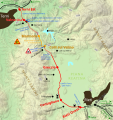
File:Tracciato Strada Statale 79 bis.svg

Original file (SVG file, nominally 5,377 × 5,701 pixels, file size: 8 MB)
Captions
Captions
Summary edit
| DescriptionTracciato Strada Statale 79 bis.svg |
Italiano: Tracciato della Strada Statale 79 bis Rieti-Terni (Italia)
English: Plan of State Road 79 bis from Rieti to Terni (Italy) |
| Date | |
| Source |
Own work; includes File:Italian traffic signs - passaggio a livello con barriere.svg and File:Italian traffic signs - lavori.svg by User:F l a n k e r, File:AB-Tank.svg by User:Qualle and File:AB-Autobahnkiosk.svg from German Code of the Road. This W3C-unspecified vector image was created with Inkscape . |
| Author | Alessandro Antonelli |
Licensing edit
- You are free:
- to share – to copy, distribute and transmit the work
- to remix – to adapt the work
- Under the following conditions:
- attribution – You must give appropriate credit, provide a link to the license, and indicate if changes were made. You may do so in any reasonable manner, but not in any way that suggests the licensor endorses you or your use.
File history
Click on a date/time to view the file as it appeared at that time.
| Date/Time | Thumbnail | Dimensions | User | Comment | |
|---|---|---|---|---|---|
| current | 14:33, 11 September 2021 |  | 5,377 × 5,701 (8 MB) | Una giornata uggiosa '94 (talk | contribs) | aggiornamento (lavori conclusi) |
| 16:02, 24 December 2020 |  | 5,377 × 5,701 (8 MB) | Una giornata uggiosa '94 (talk | contribs) | aggiorno in seguito all'inaugurazione del 22/12/2020; aggiungo i viadotti S. Carlo e Tescino che non erano indicati; font più grande per Ponte delle Marmore e Galleria Valnerina che sono le opere maggiori; cambio nome svincolo da "Marmore" a "Marmore/Piediluco" per maggiore chiarezza | |
| 16:11, 25 November 2020 |  | 5,377 × 5,701 (8.01 MB) | Una giornata uggiosa '94 (talk | contribs) | bordo nero attorno alla linea bianca, altrimenti poco visibile; reso più preciso il tracciato in corrispondenza della galleria Valnerina | |
| 23:07, 3 June 2020 |  | 5,377 × 5,701 (8 MB) | Una giornata uggiosa '94 (talk | contribs) | aggiungo il percorso del vecchio tracciato della SS79, in bianco; aggiungo altre località; aggiungo percorso del fiume Velino, del lago Lungo, della cascata delle Marmore; prolungo la linea del confine regionale; piccoli spostamenti e cambiamenti | |
| 22:50, 1 February 2019 |  | 5,377 × 5,701 (7.92 MB) | Una giornata uggiosa '94 (talk | contribs) | cambiato simbolo per i viadotti (da linea normale a linea con contorno nero); aggiunto viadotto Tancia | |
| 12:35, 17 September 2017 |  | 5,377 × 5,701 (7.92 MB) | Una giornata uggiosa '94 (talk | contribs) | added phisical map background, fixed some inscriptions | |
| 01:42, 14 May 2016 |  | 5,377 × 5,701 (85 KB) | Una giornata uggiosa '94 (talk | contribs) | ora dovrebbe andare | |
| 01:41, 14 May 2016 |  | 5,377 × 5,701 (85 KB) | Una giornata uggiosa '94 (talk | contribs) | fix testo sovrapposto | |
| 01:32, 14 May 2016 |  | 5,377 × 5,701 (85 KB) | Una giornata uggiosa '94 (talk | contribs) | migliorata la leggibilità, aggiunto del testo | |
| 22:57, 30 January 2016 |  | 5,377 × 5,701 (78 KB) | Una giornata uggiosa '94 (talk | contribs) | User created page with UploadWizard |
You cannot overwrite this file.
File usage on Commons
The following 22 pages use this file:
- User:Chumwa/OgreBot/Potential transport maps/2016 January 21-31
- User:Chumwa/OgreBot/Potential transport maps/2016 May 11-20
- User:Chumwa/OgreBot/Potential transport maps/2017 September 11-20
- User:Chumwa/OgreBot/Potential transport maps/2019 February 1-9
- User:Chumwa/OgreBot/Transport Maps/2016 January 21-31
- User:Chumwa/OgreBot/Transport Maps/2016 May 11-20
- User:Chumwa/OgreBot/Transport Maps/2017 September 11-20
- User:Chumwa/OgreBot/Transport Maps/2019 February 1-9
- User:Chumwa/OgreBot/Transport Maps/2020 December 21-31
- User:Chumwa/OgreBot/Transport Maps/2020 June 1-10
- User:Chumwa/OgreBot/Transport Maps/2020 November 21-30
- User:Chumwa/OgreBot/Transport Maps/2021 September 11-20
- User:Chumwa/OgreBot/Travel and communication maps/2016 January 21-31
- User:Chumwa/OgreBot/Travel and communication maps/2016 May 11-20
- User:Chumwa/OgreBot/Travel and communication maps/2017 September 11-20
- User:Chumwa/OgreBot/Travel and communication maps/2019 February 1-9
- User:Chumwa/OgreBot/Travel and communication maps/2020 December 21-31
- User:Chumwa/OgreBot/Travel and communication maps/2020 June 1-10
- User:Chumwa/OgreBot/Travel and communication maps/2020 November 21-30
- User:Chumwa/OgreBot/Travel and communication maps/2021 September 11-20
- User:J budissin/Uploads/BiH/2019 February 1-9
- User:Una giornata uggiosa '94
File usage on other wikis
The following other wikis use this file:
- Usage on it.wikipedia.org
Metadata
This file contains additional information such as Exif metadata which may have been added by the digital camera, scanner, or software program used to create or digitize it. If the file has been modified from its original state, some details such as the timestamp may not fully reflect those of the original file. The timestamp is only as accurate as the clock in the camera, and it may be completely wrong.
| Short title | Tracciato strada statale 79/79 bis Ternana |
|---|---|
| Width | 1517.3876mm |
| Height | 1609.0345mm |