File:Trafalgar 1200hr-es.svg

Size of this PNG preview of this SVG file: 635 × 600 pixels. Other resolutions: 254 × 240 pixels | 508 × 480 pixels | 813 × 768 pixels | 1,084 × 1,024 pixels | 2,168 × 2,048 pixels | 900 × 850 pixels.
Original file (SVG file, nominally 900 × 850 pixels, file size: 343 KB)
Captions
Captions
Add a one-line explanation of what this file represents
Summary edit
| Description |
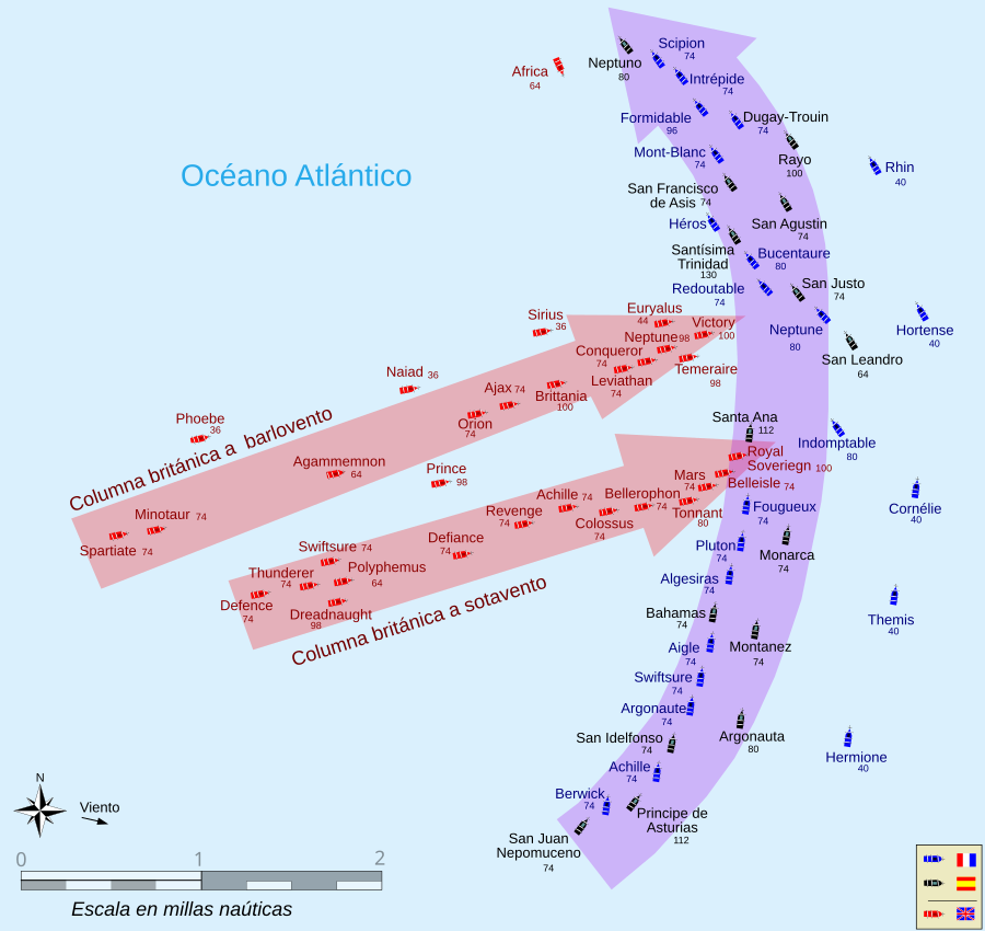
Español: Traducción al español de algunas leyendas, cambio de la escala a millas naúticas del mapa de la batalla de Trafalgar del archivo de commons Trafalgar 1200hr-fr.svg.
Muestra la posición aproximada a las 1200h cuando el Royal Sovereign rompe la linea de la escuadra franco-española. El N esta en la parte superior.English: This map of the Battle of Trafalgar shows the approximate position of the two fleets at 1200 hours during the battle as the Royal Sovereign was breaking into the Franco-Spanish line. North is to the top, and Cape Trafalgar is 10 miles to the northeast. Français : Cette carte de la Bataille de Trafalgar montre les positions approximatives des deux flottes à 12 heures de la bataille lorsque la flotte royale aborde la ligne franco-espagnole. Le nord est en haut et le cap Trafalgar est à 10 miles au nord-est. |
| Date | |
| Source |
This file was derived from: Trafalgar 1200hr.svg |
| Author | Heriberto Arrribas Abato |
Licensing edit
I, the copyright holder of this work, hereby publish it under the following license:
This file is licensed under the Creative Commons Attribution-Share Alike 3.0 Unported license.
- You are free:
- to share – to copy, distribute and transmit the work
- to remix – to adapt the work
- Under the following conditions:
- attribution – You must give appropriate credit, provide a link to the license, and indicate if changes were made. You may do so in any reasonable manner, but not in any way that suggests the licensor endorses you or your use.
- share alike – If you remix, transform, or build upon the material, you must distribute your contributions under the same or compatible license as the original.
File history
Click on a date/time to view the file as it appeared at that time.
| Date/Time | Thumbnail | Dimensions | User | Comment | |
|---|---|---|---|---|---|
| current | 08:15, 22 February 2013 | | 900 × 850 (343 KB) | H A A (talk | contribs) | Se ha añadido el número de cañones de cada barco. Una rosa de vientos indicando el norte y la dirección del viento |
| 13:30, 21 February 2013 |  | 900 × 850 (301 KB) | H A A (talk | contribs) | User created page with UploadWizard |
You cannot overwrite this file.
File usage on Commons
The following 2 pages use this file:
File usage on other wikis
The following other wikis use this file:
- Usage on ast.wikipedia.org
- Usage on es.wikipedia.org