File:Tram map of Bochum and Gelsenkirchen.xcf

Original file (1,110 × 1,050 pixels, file size: 2.9 MB, MIME type: image/x-xcf)
Captions
Captions
|
|
Summary edit
| Description |
English: Tramway network of Bochum and Gelsenkirchen, Germany Deutsch: Topographischer Netzplan des Straßenbahnnetzes in Bochum und Gelsenkirchen |
|||
| Date | ||||
| Source | openstreetmap.org | |||
| Creator |
OpenStreetMap contributors |
|||
| Permission (Reusing this file) |
OpenStreetMap data is available under the Open Database License (details). Map tiles are licensed under the Creative Commons Attribution-ShareAlike 2.0 license (CC-BY-SA 2.0).
This file is licensed under the Creative Commons Attribution-Share Alike 2.0 Generic license.
|
|||
| Georeferencing | If inappropriate please set warp_status = skip to hide. |
File history
Click on a date/time to view the file as it appeared at that time.
| Date/Time | Thumbnail | Dimensions | User | Comment | |
|---|---|---|---|---|---|
| current | 08:13, 12 February 2023 |  | 1,110 × 1,050 (2.9 MB) | Bürgerentscheid (talk | contribs) | Abzweig O-Werk ergänzt, ab 2023-01-09 |
| 16:37, 1 November 2020 |  | 1,110 × 1,050 (2.88 MB) | Bürgerentscheid (talk | contribs) | update 2020-11-01 | |
| 17:37, 11 January 2020 | 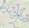 | 1,110 × 1,050 (2.88 MB) | Bürgerentscheid (talk | contribs) | Witten: track between Heven Dorf und Papenholz with regular circulation. | |
| 17:38, 21 December 2019 |  | 1,110 × 1,050 (2.88 MB) | Bürgerentscheid (talk | contribs) | updated to 2019-12-15 | |
| 06:32, 14 April 2013 | 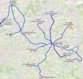 | 1,110 × 1,050 (3.01 MB) | Bürgerentscheid (talk | contribs) | {{XCF}} == {{int:filedesc}} == {{Information |Description=Tramway network of Bochum and Gelsenkirchen |Date=2013-04-14 |Author= Bürgerentscheid |Source= Openstreetmap |Permission= |other_versions=[[File:Tram map of Bochum and... |
You cannot overwrite this file.
File usage on Commons
The following 19 pages use this file:
- User:Chumwa/OgreBot/Potential transport maps/2019 December 21-31
- User:Chumwa/OgreBot/Potential transport maps/2020 January 11-20
- User:Chumwa/OgreBot/Public transport information/2019 December 21-31
- User:Chumwa/OgreBot/Public transport information/2020 January 11-20
- User:Chumwa/OgreBot/Public transport information/2020 November 1-10
- User:Chumwa/OgreBot/Public transport information/2023 February 10-18
- User:Chumwa/OgreBot/Transport Maps/2019 December 21-31
- User:Chumwa/OgreBot/Transport Maps/2020 January 11-20
- User:Chumwa/OgreBot/Transport Maps/2020 November 1-10
- User:Chumwa/OgreBot/Transport Maps/2023 February 10-18
- User:Clic/Nahverkehr in Deutschland/2019 December 21-31
- User:Clic/Nahverkehr in Deutschland/2020 January 11-20
- User:Clic/Nahverkehr in Deutschland/2020 November 1-10
- User:Clic/Nahverkehr in Deutschland/2023 February 10-18
- User:Holger1959/EN
- User:Nordlicht8/Rail Germany/2019 December 21-31
- User:Nordlicht8/Rail Germany/2020 January 11-20
- User:Nordlicht8/Rail Germany/2020 November 1-10
- User:Nordlicht8/Rail Germany/2023 February 10-18
File usage on other wikis
The following other wikis use this file:
- Usage on de.wikipedia.org
- Usage on en.wikipedia.org
- Usage on fa.wikipedia.org
- Usage on fr.wikipedia.org
- Usage on it.wikipedia.org
- Usage on ja.wikipedia.org
- Usage on nl.wikipedia.org
- Usage on pt.wikipedia.org
- Usage on ru.wikipedia.org