File:Trambaix.svg

Size of this PNG preview of this SVG file: 800 × 395 pixels. Other resolutions: 320 × 158 pixels | 640 × 316 pixels | 1,024 × 505 pixels | 1,280 × 632 pixels | 2,560 × 1,263 pixels | 1,431 × 706 pixels.
Original file (SVG file, nominally 1,431 × 706 pixels, file size: 63 KB)
Captions
Captions
Add a one-line explanation of what this file represents
Summary edit
| Description |
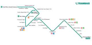
Català: Mapa actualitzat del Trambaix. English: Current map of the Trambaix network. Français : Plan actuel du réseau Trambaix. |
| Source | Own work |
| Author | Vinals |
Licensing edit
I, the copyright holder of this work, hereby publish it under the following licenses:
This file is licensed under the Creative Commons Attribution-Share Alike 3.0 Unported license.
- You are free:
- to share – to copy, distribute and transmit the work
- to remix – to adapt the work
- Under the following conditions:
- attribution – You must give appropriate credit, provide a link to the license, and indicate if changes were made. You may do so in any reasonable manner, but not in any way that suggests the licensor endorses you or your use.
- share alike – If you remix, transform, or build upon the material, you must distribute your contributions under the same or compatible license as the original.

|
Permission is granted to copy, distribute and/or modify this document under the terms of the GNU Free Documentation License, Version 1.2 or any later version published by the Free Software Foundation; with no Invariant Sections, no Front-Cover Texts, and no Back-Cover Texts. A copy of the license is included in the section entitled GNU Free Documentation License. |
You may select the license of your choice.
File history
Click on a date/time to view the file as it appeared at that time.
| Date/Time | Thumbnail | Dimensions | User | Comment | |
|---|---|---|---|---|---|
| current | 21:31, 12 February 2022 | | 1,431 × 706 (63 KB) | Meierberg (talk | contribs) | Update interchanges with Metro lines 5 and 9 and replace station names with SVG text, instead of text converted to paths |
| 15:46, 12 April 2010 |  | 1,431 × 706 (16.66 MB) | Vinals (talk | contribs) | == Summary == {{Information |Description={{ca|1=Mapa actualitzat del Trambaix.}} |Source={{own}} |Author=Vilarrubla |Date= |Permission= |other_versions= }} Category:Trams in Barcelona [[Category:Public transport maps of Barcelona] | |
| 19:16, 4 April 2010 |  | 825 × 458 (17.83 MB) | Vinals (talk | contribs) | == Summary == {{Information |Description={{ca|1=Mapa actualitzat del Trambaix.}} |Source={{own}} |Author=Vilarrubla |Date= |Permission= |other_versions= }} Category:Trams in Barcelona [[Category:Public transport maps of Barcelona] | |
| 23:38, 3 April 2010 |  | 1,650 × 917 (17.85 MB) | Vinals (talk | contribs) | {{Information |Description={{ca|1=Mapa actualitzat del Trambaix}} |Source={{own}} |Author=Vilarrubla |Date= |Permission= |other_versions= }} Category:Rail transport in Catalonia |
You cannot overwrite this file.
File usage on Commons
The following 5 pages use this file:
File usage on other wikis
The following other wikis use this file:
- Usage on ca.wikipedia.org
- Usage on de.wikipedia.org
- Usage on en.wikipedia.org
- Usage on eo.wikipedia.org
- Usage on es.wikipedia.org
- Usage on fr.wikipedia.org
- Usage on gl.wikipedia.org
- Usage on hu.wikipedia.org
- Usage on it.wikipedia.org
- Usage on lmo.wikipedia.org
- Usage on ru.wikipedia.org
- Usage on sv.wikipedia.org
- Usage on uk.wikipedia.org
- Usage on www.wikidata.org