File:Transilvania harta etnica 1850.png

Size of this preview: 800 × 540 pixels. Other resolutions: 320 × 216 pixels | 640 × 432 pixels | 1,024 × 691 pixels | 1,515 × 1,022 pixels.
Original file (1,515 × 1,022 pixels, file size: 209 KB, MIME type: image/png)
Captions
Captions
Add a one-line explanation of what this file represents
Summary edit
| Description |
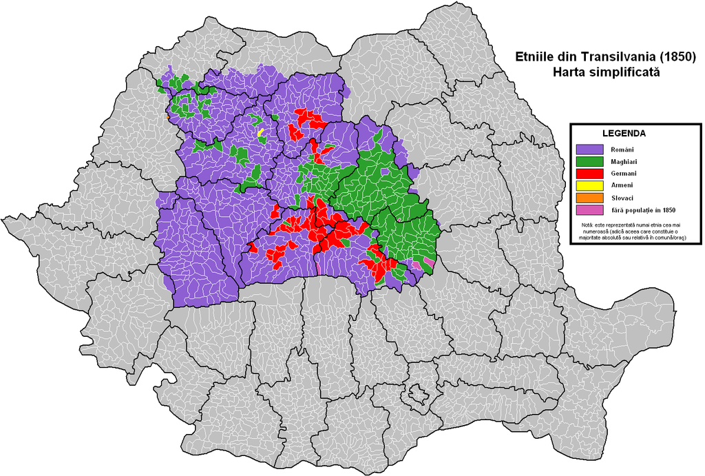
Română: Harta etnică a Transilvaniei, pe baza datelor recensământului habsburgic din anul 1850. Harta reprezintă limitele administrative actuale: judeţe, comune, oraşe. |
| Date | |
| Source | Own work |
| Author | Olahus |
Licensing edit
I, the copyright holder of this work, hereby publish it under the following license:
This file is licensed under the Creative Commons Attribution-Share Alike 3.0 Unported license.
- You are free:
- to share – to copy, distribute and transmit the work
- to remix – to adapt the work
- Under the following conditions:
- attribution – You must give appropriate credit, provide a link to the license, and indicate if changes were made. You may do so in any reasonable manner, but not in any way that suggests the licensor endorses you or your use.
- share alike – If you remix, transform, or build upon the material, you must distribute your contributions under the same or compatible license as the original.
File history
Click on a date/time to view the file as it appeared at that time.
| Date/Time | Thumbnail | Dimensions | User | Comment | |
|---|---|---|---|---|---|
| current | 22:51, 11 December 2011 | | 1,515 × 1,022 (209 KB) | Olahus (talk | contribs) | Predeal |
| 22:50, 11 December 2011 |  | 1,514 × 1,022 (212 KB) | Olahus (talk | contribs) | Predeal | |
| 22:12, 18 August 2011 |  | 1,515 × 1,022 (209 KB) | Olahus (talk | contribs) |
You cannot overwrite this file.
File usage on Commons
The following page uses this file:
File usage on other wikis
The following other wikis use this file:
- Usage on ro.wikipedia.org
- Usage on uk.wikipedia.org